|
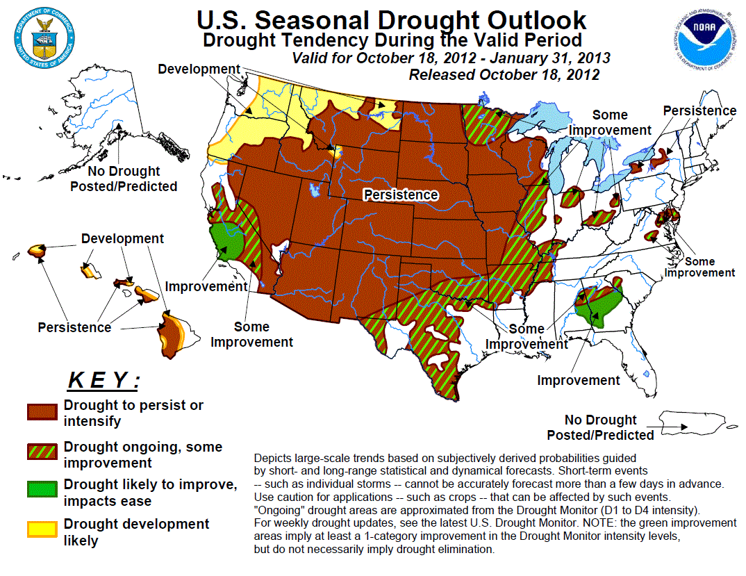
Discussion for the Seasonal Drought Outlook
Tools used in the U.S. Drought Outlook (USDO) included the official CPC temperature and precipitation outlooks
for November 2012 and the long lead forecast for November 2012 through January 2013, various medium- and short-range
forecasts and models such as the 6-10 day and 8-14 day forecasts, the most recent 384-hour GFS total precipitation amounts,
the soil moisture tools based on the Constructed Analog on Soil (CAS) moisture, the Climate
Forecast System (CFS, versions 1 and 2), the four-month Palmer drought termination and amelioration probabilities, climatology,
and initial conditions. Some consideration was also given to the El Niño precipitation anomalies for November through January due to the possibility of a weak
El Niño event.
During the previous week, rainfall and high elevation snow overspread western Washington and Oregon, increasing streamflows and
eliminating areas of abnormal dryness (D0) west of the Cascades that had developed during September. This wet pattern is
expected to continue in the short term, with an additional 3 to 5 inches of liquid accumulation forecast along the coastal
ranges and Cascades during the upcoming five days. The CPC 6-10 and 8-14 day forecasts indicate a high probability of this
storminess continuing into the week 2 period. Beyond the medium range, however, both the CPC November monthly and NDJ seasonal
outlooks tilt the odds in favor of below median precipitation across the Pacific Northwest. In fact, the models and tools used
to construct the CPC long lead forecasts were unanimous indicating an abnormally dry late fall and early winter, which is a
climatologically wet time of year for the Northwest. Additionally, due to the warmer climatology of mid-October, the short
term precipitation will likely have less of an impact on the winter snow pack development in comparison to storms that occur
later in the period when the odds are tilted towards dryness. Based on these long range outlooks, the expectation for drought
development introduced in the OND outlook continues into the NDJ period east of the Cascades, with persistence expected in
areas of existing drought. The potential for new drought development by mid-winter is less certain in the areas closer to the
coast due to the ongoing short term wetness.
Forecast confidence for the Northwest is moderate.
Dry weather persisted across California's Sacramento Valley during the past two weeks, while light to moderate rainfall fell
across the southern coastline and mountains. Locally heavy rainfall brought drought relief to portions of the lower Sierras
and Mojave Desert. The November through January period is climatologically wet throughout much of California, with coastal
regions receiving more than 50 percent of their annual rainfall during this period. Some short term rainfall is expected
across northern California as a series of storms impacts the Pacific Northwest, contrasting with drier conditions forecast
across the desert Southwest. The CPC seasonal outlook tilts the odds in favor of below median precipitation across northern
California, while maintaining equal chances for southern California eastward through the southern Rockies. In the presence of
El Niño conditions, rainfall across California is typically enhanced, though even with seasonable rainfall the probability of
drought amelioration is high across central California due to the wet climatology. Therefore, improvement is expected across
the climatologically wettest portions of central and southern California, with some improvement indicated across the remainder
of the central Valley, Sierras, and desert regions. Further east, drought persistence is expected across the desert Southwest
and Great Basin following the end of the monsoon season.
Forecast confidence for the Southwest is moderate.
Scattered precipitation fell across the central Rockies during the previous two weeks, with the heaviest amounts accumulating
in northern Colorado. Despite the recent rains, 28 day streamflows remain generally below normal across the central Rockies.
The CPC 6-10 and 8-14 day outlooks indicate enhanced chances of below normal precipitation for the central and southern Rockies,
while the monthly and seasonal guidance maintain equal chances. The central Rockies trend slightly drier climatologically
during the late fall and early winter. Based on initial conditions and the dry medium range outlooks, drought persistence is
expected, but with a low forecast confidence.
Forecast confidence for the central Rockies is low to moderate.
Scattered to widespread rainfall fell across central and eastern Texas, eastern Oklahoma, and much of Kansas during the
previous two weeks, bringing some drought relief to the eastern Plains, while widespread exceptional drought continues across
the remainder of the central Plains. Some additional widely scattered precipitation is possible across Texas during the
upcoming week, but drier weather is expected to return to the central Plains. The CPC extended range forecasts indicate
enhanced chances of below average rainfall across the southern and central Plains in week 2, with enhanced chances of above
average rainfall in the northern Plains. The November monthly outlook tilts the odds towards below median precipitation in the
east-central Plains, while the seasonal outlook maintains equal chances. The late fall and early winter period is
climatologically dry across the central and north central U.S. as Gulf moisture retreats southeastward into the Delta region.
Based on this climatology, little impact to drought is expected during the upcoming three month period. Therefore, persistence
is expected across the central and northern Plains. In Texas, climatological precipitation has a moderate probability of
ameliorating the current drought conditions. If weak El Niño conditions develop during the winter season, enhanced rainfall is
possible across central and southern Texas, though confidence is quite low. Therefore, some improvement is indicated in this
outlook.
Forecast confidence is low across Texas, and high across the central and northern Plains.
Widespread rainfall overspread the Midwest, Mississippi Valley, and Great Lakes regions, bringing drought relief. An
additional widespread 1 to 2 inches of rainfall is expected from northern Mississippi through Wisconsin and much of Minnesota
during the upcoming five days, which will build on the ongoing drought improvements. The CPC extended range outlooks forecast
greater chances of above average precipitation across the upper Midwest, Great Lakes, and upper Mississippi Valley during the
week 2 period as well, although drier conditions are expected across the lower Mississippi Valley. The CPC November outlook
indicates enhanced chances of below median precipitation across the mid-Mississippi Valley, while the NDJ seasonal outlook
tilts the odds drier across the Midwest and upper Mississippi Valley. The late fall and early winter period is a
climatologically dry time of year for the Midwest, and with the growing season over across much of the region, the lack of
transpiration may allow the short term rainfall to more efficiently recharge the soil moisture and streamflows ahead of the
winter freeze. Therefore, some improvement is indicated across areas expected to receive the heaviest short term precipitation,
and persistence is maintained elsewhere.
Forecast confidence for the Midwest is moderate.
Areas of extreme to exceptional drought persisted across portions of the central Georgia piedmont and east central Alabama
with little change during the previous two weeks. To the northeast, areas of abnormal dryness expanded in the eastern
Carolinas, while moderate to severe drought remained entrenched in the Delmarva. While some scattered rainfall is likely
during the upcoming five day period, the Southeast and mid-Atlantic will largely miss out on the heavier rainfall expected to
fall across the Northeast and coastal New England. Week two outlooks indicate a greater possibility of continued dryness as
well. While the CPC November outlook maintains equal chances for above, near, or below median rainfall across the Southeast,
the NDJ seasonal outlook forecasts enhanced chances of above median rainfall across the Gulf Coast and Georgia's coastal
Plain. Given seasonal precipitation, the probability of drought amelioration across the Southeast is moderate to high. Based
on these considerations, improvement is expected across the southernmost drought regions of Georgia and Alabama, and some
improvement is indicated for the remainder of the Southeast and mid-Atlantic.
Forecast confidence for the Southeast and mid-Atlantic is moderate.
Recent storminess brought some improvement to drought areas across upstate New York. Additional widepsread rainfall is
forecast across the Northeast during the short term, with the heaviest precipitation expected east of the drought areas.
Although CPC's week 2 forecast tilts the odds slightly in favor of enhanced precipitation, the monthly and seasonal guidance
maintain equal chances of below, near, or above median precipitation. Given seasonal precipitation during the late fall and
early winter, there is a moderate probability of drought amelioration. During El Niño winters, however, New England generally
receives below average snowfall outside of the lake-effect belts. The seasonal outlooks indicating below median precipitation
across the Ohio Valley region indicate a tilt towards El Niño conditions, so based on this consideration, a low confidence
persistence forecast is maintained for these small drought areas.
Forecast confidence for upstate New York is low.
Severe to extreme drought remains entrenched across the leeward side of the Hawaiian islands. Although the climatology
becomes wetter during the winter season, seasonal guidance maintains enhanced chances of below median precipitation. Therefore,
persistence is maintained for this outlook, with some eastward encroachment of drought possible in areas already abnormally
dry. Some improvement based on climatology becomes more likely in the latter half of the winter season.
Forecast confidence for Hawaii is moderate to high.
|


