|
Latest Seasonal Assessment -
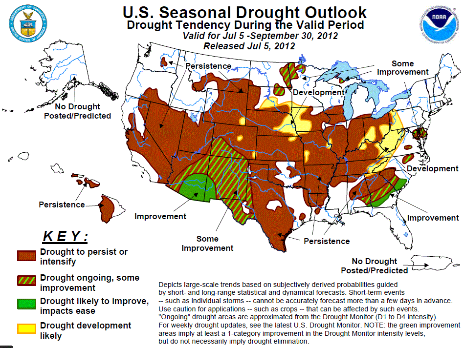
Dryness and drought have been increasing both in extent and intensity across much of the Ohio and Tennessee
Valleys, the Corn Belt region, the middle and lower Mississippi Valley, and much of the Great Plains. Drought is
likely to develop, persist or intensify across these areas. Scattered relief may come in the form of cold front
passages or organized thunderstorm clusters (MCSs), but for the most part, summers are usually a fairly dry time
of year for the central part of the nation. For the northern tier states, such as North Dakota, Minnesota, and
upper Michigan, chances are better for getting frontal passages since these areas reside close to the average
position of the polar jet stream during the summer. In the Southeast, drought improvement is expected across
coastal portions of Georgia and South Carolina, due to the greater likelihood of a tropical cyclone affecting
these areas, and also from sea-breeze driven thunderstorm activity. Across the Southwest, at least some
improvement is anticipated across much of Arizona and New Mexico, with the seasonal monsoon starting to ramp up.
At this time, it is uncertain as to how widespread or intense this years monsoon is likely to be. Finally,
drought persistence is the best bet across the remaining portions of the Western U.S., given that summertime is
usually their dry season.
|
|
Tools used in the U.S. Drought Outlook (USDO) included the official CPC temperature and precipitation outlooks
for July 2012 and the long lead forecast for July through September 2012, various medium- and short-range forecasts and
models such as the 6-10 day and 8-14 day forecasts, the most recent 384-hour GFS total precipitation amounts, the
soil moisture tools based on the Constructed Analog on Soil (CAS) moisture, the Climate Forecast System (CFS, versions 1 and 2),
the four-month Palmer drought termination and amelioration probabilities, climatology, and initial conditions.
AHPS Departure from Normal Precipitation (DNP) for the last 14 days reveals significant positive departures
(ranging from 5 to 8 inches, locally even greater) across northern and west-central portions of Florida,
and extreme southeastern Georgia. These excesses are due to the passage of two Tropical Storms, Beryl and
Debby. Except for this region, and the northeastern corner of North Carolina which depicts an excess of
locally up to 2 inches for the period, the remainder of the Southeast has been dry, with deficits ranging
from 1 to 3 inches. The extended-range forecasts (6-10 day and 8-14 day) anticipate elevated odds of
near- to above-median rainfall across the Southeast. Though CPC’s updated monthly outlook for July calls
for Equal Chances (EC) of below-, near-, and above-median precipitation across the Southeast, the seasonal
outlook for July-September, as well as the CFSv2 model, favors wetter-than-median conditions over a large
portion of the region. In addition, the odds for at least some improvement are elevated closer to the
coast, which is often affected by sea-breeze driven thunderstorm activity.
Forecast confidence for the Southeast is moderate.
During the past 2 weeks, light to moderate rainfall (under 2 inches) over the Northeast and mid-Atlantic
has helped to offset encroaching dryness in the region. On Friday, June 29, an MCS developed over eastern
Iowa and tracked southeastward across the Ohio Valley and central Appalachians, eventually reaching the
mid-Atlantic coastal plain by the late evening hours. The MCS had developed into a cluster of very strong
downbursts which brought hurricane-force winds to much of the Washington, D.C. area, bringing down trees
and electric power grids, and leaving several million people without power for days. Unfortunately, this
storm knocked out power to many air conditioners during a record or near-record heat wave, with Washington
National Airport reporting a high temperature of 104 degrees F earlier that day. This type of system with
very strong straight-line winds is known as a “derecho”, and gets its name from the Spanish word
meaning “straight ahead”. Once again, the bulk of the rain that fell in the mid-Atlantic region missed the
area that needs it most – central and southern Delaware, and adjacent parts of Maryland’s Eastern Shore.
This core drought area shows up clearly in the DNP’s out through the past 180 days. Although short- and
extended-range predictions favor a slight tilt in the odds towards above-median rainfall, there are no
clear indications at this time for significant mitigation of the core drought area at least for the
duration of the summer.
Forecast confidence for the Northeast and Mid-Atlantic regions is moderate.
Much of the Corn Belt continues to experience increasing dryness and drought, with DNP’s over the past 30
days on the order of 3 to 5 inches across central and eastern Iowa and much of Illinois and Indiana.
Current NLDAS soil moisture anomalies (Ensemble Mean LSM, total column) reveal widespread moisture deficits
on the order of 4 to 6 inches. Current root-zone (top 1-meter) soil moisture deficits range from 2 to 5
inches across this region. For the first few days of this Seasonal Drought Outlook, an upper-air ridge over
the region is expected to divert the storm track to the north and east of the Corn Belt. The CPC 6-10 day,
8-14 day, and 30-day Outlooks call for enhanced chances of below-median rainfall and near- to above-normal
temperatures for the region. CPCs official predicted 500-mb height pattern for the extended range has the
southern edge of the westerlies in the vicinity of the Corn Belt. If correct, it suggests at least the
potential for organized thunderstorm clusters (MCSs) to bring relief to parts of the area. However, the
chances of this occurring will be countered by the self-perpetuation of regional drought conditions, with
very dry soils and very limited evapotranspiration. The 90-day Outlook for July-September indicates
increased odds of above-normal temperatures, but with no clear precipitation signal for the region, EC is
favored.
Forecast confidence for the Corn Belt is moderate.
Across the lower/middle Mississippi Valley and the Tennessee and Ohio Valleys, DNPs spanning the most
recent 2 weeks depict mostly 1 to 3 inch deficits. Over the past 60 days, AHPS DNPs show widespread
deficits across most of the region, most notably over western Arkansas and northern Louisiana where the
greatest precipitation deficits range from 8 to 12 inches. Dryness has been increasing across central and
eastern portions of both the Ohio and Tennessee Valleys. NLDAS Soil Moisture models currently show total
column deficits of 2 to 4 inches in these areas, and in some spots even greater. Prospects for relief at
all time scales through the JAS 2012 seasonal outlook appear rather limited at this time. Therefore,
drought development is anticipated over the upper halves of both the Ohio and Tennessee Valleys.
Forecast confidence for the lower/middle Mississippi Valley and the Ohio and Tennessee Valleys is moderate.
Over a large portion of the upper Mississippi Valley and northern Great Plains, widespread precipitation
was reported over the course of the past 2 weeks. However, the DNPs for the same period show that a
significant portion of the region is experiencing 1 to 2 inch deficits. This latter area includes eastern
and southern North Dakota, much of South Dakota, northern and southwestern Minnesota and southern
Wisconsin. A few areas have experienced rainfall surpluses, but by far the most notable area is in and
around the twin ports of Duluth, Minnesota and Superior, Wisconsin. Two weeks ago, slow-moving
thunderstorms brought torrential rains (8 to 10 inches) to this area, resulting in numerous sinkholes and
flooding problems. Occasional fronts and associated thunderstorm activity have helped keep this general
area in decent shape. During the summer months, the polar jet stream tends to remain near the Canadian
border, so this region (as well as Wisconsin and upper Michigan) can expect continued cool front passages,
in addition to organized thunderstorm clusters (MCSs). Therefore, some improvement is considered the best
bet for most of this region.
Forecast confidence for the upper Mississippi Valley/Northern Plains is moderate.
In the central and southern Great Plains region, an area of heavy rainfall (2 inches or greater) was
observed during the last 14-days over sections of southeastern Nebraska and adjacent northeastern Kansas,
and near the Texas Coast. During the last 60 days, rainfall deficits of 2 to 4 inches (locally even
greater) accumulated over central and eastern portions of Texas, 4 to 8 inches over much of Oklahoma and
Kansas, and 2 to 6 inches across Nebraska. For the first 5-days of this outlook, the persistent upper-air
ridge over the central portion of the CONUS will continue to steer moisture and storms around its
periphery, resulting in little to no rainfall for the central and southern Plains. Instead, the arc-shaped
moisture corridor favors monsoonal moisture heading northward through the southern and central Rockies,
then turning northeastward across the Dakotas and upper Mississippi Valley, and continuing southeastward
from there across the Ohio Valley and southern Appalachians. The CPC extended-range precipitation forecasts
favor slight relief over Texas. CPCs 30-day and 90-day outlooks favor a tilt in the odds for above-normal
temperatures for both July and July-September. The precipitation outlooks for these same time periods are
less certain, with Equal Chances predicted for most areas. The best chances for below-median rainfall is
across eastern sections of both Nebraska and Kansas in July.
Forecast confidence for the central/southern Plains is moderate.
Increasing monsoonal flow across the Southwest heralds the seasonal onset of the Summer Monsoon. Typically,
it takes some time for upper-level moisture to work its way down to the desert floor (column moistening),
so dry thunderstorms, blowing dust, and wildfire starts are more likely. As the atmosphere becomes more
saturated, potential hazards shift to heavy rainfall and flash flooding. In the next 5-days, rainfall
deficits that have accumulated over the past few months are expected to be offset in many areas with up to
2 inches of monsoonal rain. Even for very dry western Colorado, 2 inches of rain would eliminate a
significant fraction of the 2 to 4 inch deficits that accumulated over the past 60 days. CPCs precipitation
outlook suite for the extended-, monthly-, and seasonal ranges (as well as the seasonal CFSv2 forecast)
favor near- to above-median rainfall across this region.
Forecast confidence for the Southwest is low to moderate.
Widespread moderate to severe drought covers much of the remainder of the Southwestern U.S. While the
Southwestern Monsoon can bring moisture throughout the Four Corners States, the summer is climatologically
dry across the Great Basin, California, and the Northwest. CPCs monthly and seasonal outlooks favor
enhanced odds of below-median precipitation over the Northwest, and above-median precipitation over parts
of Arizona and New Mexico.
Forecast confidence for the remainder of the West is high.
The summer months are climatologically dry in Hawaii. Therefore, little improvement in existing drought
areas is expected through September.
Forecast confidence for Hawaii is high.
|


