|
Latest Seasonal Assessment -
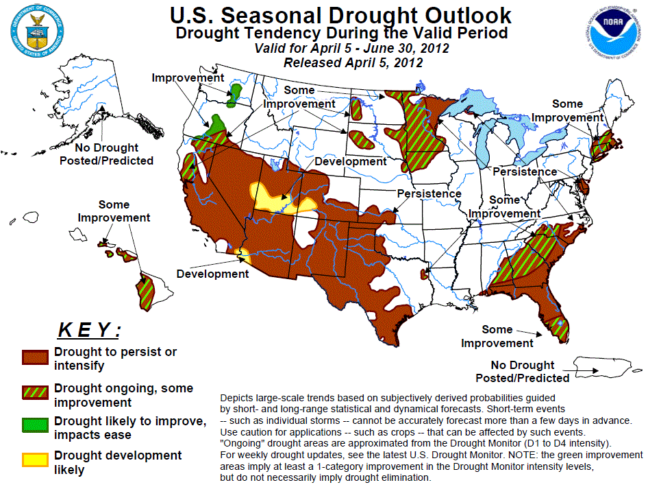
The Drought Outlook for April 5 – June 30, 2012 is based on short-, medium-, and long-range forecasts, initial
conditions, and climatology. Since the release of the previous Drought Outlook issued on March 15, 2012, drought
was eradicated in some areas from northern California into eastern Washington, across parts of the southern Great
Plains, along the central Gulf Coast, and in northern North Carolina. In contrast, warm and dry weather led to
drought development in parts of the Northeast, the northern High Plains, and a few areas in central sections of
the Rockies and eastern Great Basin. Overall, the current Drought Outlook extending into early summer is not
optimistic. Improvement, or at least some improvement, is expected in west-central and northwestern parts of the
country, where above-normal precipitation is forecast through the end of April and the ensuing seasonal dryness
of May and June allows little opportunity for changes in longer-term precipitation anomalies during those months.
Farther east and south, from central California, the Great Basin, and the Southwest through southern sections of
the Plains, dry conditions are favored in various (but in all cases large) parts of the region for time periods
ranging from the next 5 days through the 3-month outlook valid April – June 2012, keeping drought intact with
some expansion expected in areas of the central Rockies and southwestern Arizona not currently experiencing
drought. For areas in drought across the northern Plains, upper Midwest, and eastern tier of states, persistence
or only limited improvement is expected. The areas forecast to experience limited improvement have enhanced
chances for above-normal precipitation into late April and/or are moving into a climatologically wet time of year
(which provides more opportunity for improvement later in the period). In the Northeast, relatively short-term
drought and no discernible tilt of the odds toward wet or dry conditions for the next few months implies that
some improvement will be the most likely outcome.
|
|
Tools used in the U.S. Drought Outlook (USDO) included the official CPC temperature and precipitation outlooks
for April 2012 and the long lead forecast for April through June 2012,
various medium- and short-range forecasts and models such as the 6-10 day and
8-14 day forecasts, the most recent 384-hour GFS total precipitation amounts, the soil moisture tools
based on the Constructed Analog on Soil (CAS) moisture, the Climate Forecast System (CFS, versions 1 and 2), the
four-month Palmer drought termination and amelioration probabilities, climatology, and initial conditions.
Along the eastern tier of states, there are enhanced chances for above-normal precipitation across the
interior Southeast through the rest of April, and either no discernible tilt of the odds or a slight
favoring of drier than normal weather through the rest of the forecast period. Given the protracted dryness
affecting this region, but also considering that the region is moving toward a somewhat wetter time of year,
some improvement seems the most prudent forecast. Across the rest of the Southeast, precipitation forecasts
for the various time periods are either neutral or leaning dry, and thus drought conditions should remain
intact. The only exception is in southern Florida, where some improvement is forecast based on the fact
that 10 to 20 percent of annual rainfall typically occurs during June, providing more opportunity for
improvement late in the period. In the Northeast, neither dryness nor wetness is favored following the
dryness expected into late April; however, climatology does trend slightly wetter late in the period, and
the short-term nature of the drought there means it would not take enormous amounts of precipitation to
provide some improvement.
Forecast confidence for the Southeast is moderate, and for the Northeast is low.
In the upper Midwest and northern Plains from Minnesota westward, anywhere from 35 to 50 percent of the
annual precipitation falls during April – June. Thus, while there is no tilt of the odds toward dryness or
wetness for any time period, the opportunity for drought-improving precipitation increases, and thus some
improvement is forecast. Farther east, the odds favor dryness through most of April, and the April – June
period typically is not as wet (relative to the rest of the year) as in areas farther west, so drought is
expected to persist there.
Given the lack of indicators favoring wetness or dryness after late April, forecast confidence throughout
the region is low.
In southern sections of the High Plains and Great Plains, below-normal precipitation appears likely through
the end of April (after some moderate rains in southwest Texas until mid-April). In addition, the April –
June period as a whole features enhanced chances for below-normal precipitation in Colorado. Climatology is
neutral to slightly wet for April – June as a whole, but does increase for the month of June, when 10 to
nearly 20 percent of annual precipitation usually falls outside of southwest Texas. However, given the
protracted, entrenched nature of the drought, little change in assessed drought conditions seems the most
likely outcome, although a decent chance for at least some improvement must be acknowledged.
Forecast confidence for the southern Plains is low.
Across the southern halves of the Rockies and Intermountain West, the Great Basin, and the Southwest, most
indicators favor a dry April, and odds tilt toward dryness for the April – June period as a whole outside
the southern tier of the region. Furthermore, this period is typically very dry climatologically across
Arizona and western New Mexico (areas where there are no enhanced chances for either drier- or
wetter-than-normal conditions). Typically only 5 to 15 percent of annual precipitation falls during April –
June there. The combination of all these factors indicates that drought conditions will continue
essentially unchanged through the period.
Forecast confidence across the southern halves of the Rockies and Intermountain West, the Great Basin, and
the Southwest is high.
Across central and northern California, southern Oregon, part of northwestern Nevada, and eastern
Washington, wetter than normal conditions appear likely for the month of April. Conditions dry out
climatologically for most of the region after that, so the drier than normal May and June conditions
expected for the southern sections of this region should have little effect on precipitation anomalies.
Improvement or some improvement is forecast, with increasing optimism as one moves northward and westward.
Forecast confidence is high across Oregon and Washington and moderate farther south.
Some improvement is forecast for the drought areas in Hawaii, but it should be noted that chances for any
improvement will dwindle as the period progresses since the state is transitioning into a drier time of
year.
Forecast confidence in Hawaii is low.
|


