|
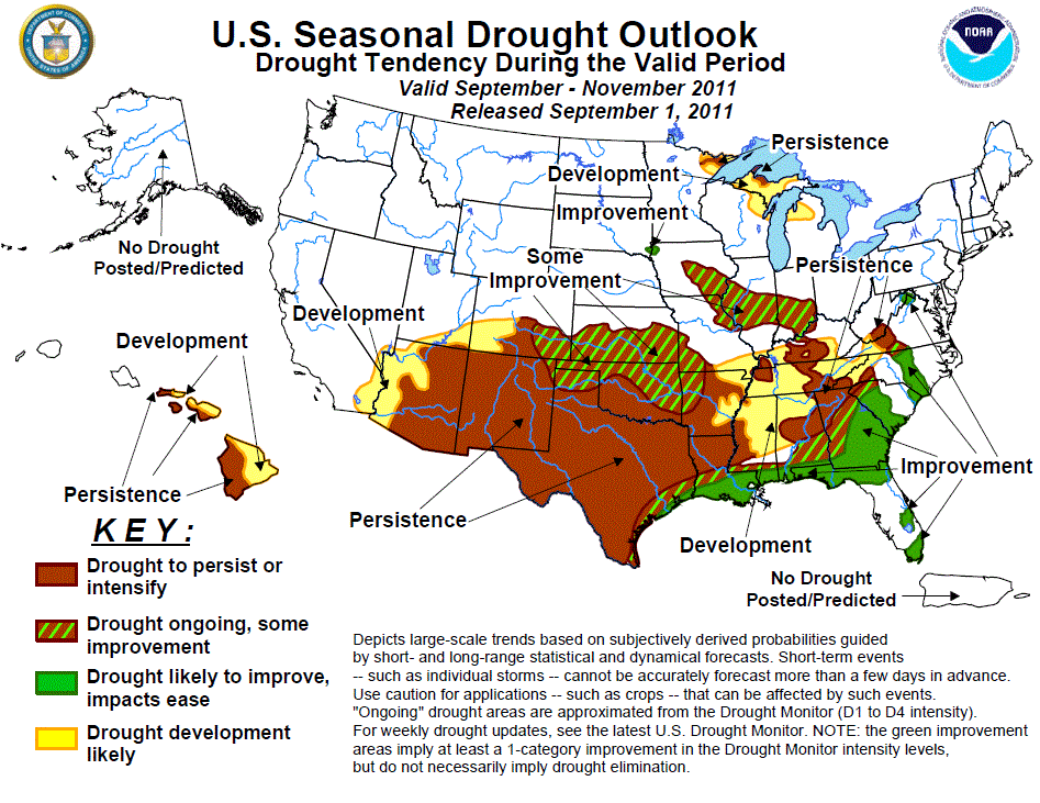
Latest Seasonal Assessment -
During late August, although ENSO-neutral conditions were present across the equatorial Pacific, the atmospheric
patterns continue to reflect La Niña-like conditions, and sea surface temperature anomalies became increasingly
negative in the east-central equatorial Pacific Ocean. As we progress into the Fall in the Northern Hemisphere,
ENSO-neutral conditions are expected to continue, with ENSO-neutral or La Niña equally likely thereafter. In the
United States, drought attributed to the past La Niña event (Fall 2010-Spring 2011) persisted in the southern
Plains. August rainfall continued below normal, especially in eastern New Mexico and most of Texas, although
Oklahoma generally recorded seasonable totals. Similar to July, August also brought near-record heat to the
southern Plains, with August temperatures averaging 4 to 8 degrees F above normal and most days exceeding
triple-digit highs. Subnormal August rains also fell along the western two-thirds of the Gulf Coast, and into
most of the Southeast except for Arkansas and Florida. Drier than normal conditions also occurred from the upper
Midwest southeastward into the Tennessee Valley. In contrast, Hurricane Irene (August 25-29) dumped copious rains
(8 to 14 inches) on the eastern Carolinas northward into the Northeast, erasing drought but causing extensive
flooding in many areas. The Southwestern monsoon remained a mixed bag, with surplus rains falling on eastern
Arizona and western New Mexico and parts of southern California, but subnormal rains reported in western Texas
and eastern New Mexico, western Arizona, and southern Utah. Elsewhere, little or no rain fell on the Pacific
Northwest (normally low August totals), while surplus rains occurred in the north-central Rockies and Plains and
eastern Ohio Valley. With the assumption that a weak La Niña event will develop this fall (e.g. back to back La
Nina years), drought should persist and expand from the Southwest eastward into the interior Southeast by the end
of November. Likewise, drier conditions are predicted for the upper Great Lakes region as per the consecutive La
Niña year composites. The south-central Plains, however, were labeled some improvement due to a slight wet
correlation during the second year of a La Niña and increased rains during August. In contrast, additional
improvement is anticipated across the southern and middle Atlantic Coasts due to an expected above-normal
Atlantic Hurricane season, CPC's September precipitation outlook, and consecutive La Niña second year composites.
And with expected short to medium term and September wetness along the immediate Gulf Coast, a thin band of
improvement and some improvement was added to reflect this update; however, if this tropical moisture fails to
materialize during September, drought is expected to persist and intensify in the western and central Gulf Coast.
Across Hawaii, leeward drought persistence is expected, with some moderate drought development in the southern
islands currently in D0 (abnormal dryness) based upon forecasted subnormal Fall precipitation from CPC. No
drought is expected/forecasted for Alaska or Puerto Rico.
|
|
Tools used in the U.S. Drought Outlook (USDO)
included the official CPC temperature and precipitation outlooks for September 2011
and the long lead forecast for September - November 2011, various medium- and short-range forecasts and
models such as the 6-10 day and 8-14 day forecasts, the soil moisture
tools based on the GFS model and the Constructed Analogue on Soil (CAS) moisture, the Climate Forecast
System (CFS) seasonal precipitation forecasts, the four-month Palmer drought termination and amelioration
probabilities, climatology, and initial conditions.
A persistent ridge of high pressure
maintained hot and dry conditions across the south-central U.S. into August, exacerbating the drought in the
southern Plains. August temperatures averaged 4 to 8 deg F in Texas and Oklahoma, with most days topping 100
degrees F. This summer will go down into the record books as the hottest ever for most stations across Texas
and Oklahoma. From Shreveport, LA, to Oklahoma City, OK, to nearly all of Texas except El Paso, the summer of
2011 will go down as the hottest on record. The biggest departure from the previous record was in San Angelo,
TX, where the 2011 summer average temp of 89.3 F was 3.7 degrees F higher than the previous record. Not far
behind was Wichita Falls and Lubbock, each of which were 3.3 degrees F above the previous record. Fortunately,
some relief finally arrived across Kansas and most of Oklahoma during early to mid-August where 3-6 inches of
rain fell. Parts of central and southwestern Texas also recorded decent (2-4 inches) rain, but it only provided
minimal relief as the warmth persisted in Texas. The Fall is typical drier across the southern Plains, although
October is one of the normally wetter months in Texas due to tropical Gulf activity and northern cold fronts
dropping into the Lone Star state. The medium and extended range forecasts indicate enhanced chances for
below-median rainfall across the southern Plains states, except along the immediate Gulf Coast where heavy
rains are expected. The CPC September and Fall outlooks maintain elevated chances of below-median rainfall for
most of the southern Great Plains and lower Southwest and indicate elevated odds for above-normal temperatures
- except for the updated monthly outlook which forecasts favorable odds of above-normal rains along the Gulf
Coast. Using the assumption of a La Niña developing later this fall, the composite back to back La Niña
anomalies indicate subnormal precipitation for the Southwest and western and central Gulf Coasts, with a very
slight hint of wetness in the southern High Plains. However, any landfalling tropical systems in the western
Gulf during the Fall could provide relief to southeastern Texas, similar to what the updated monthly
precipitation outlook depicted. Based on these outlooks, continued drought persistence is likely for the
southern Plains (if no landfalling tropical systems or forecasted September wetness fails to materialize),
with a chance for improvement and some improvement along the western Gulf Coast (low confidence), some slight
and spotty improvement in parts of the southern High Plains (low confidence) and the northern edge of the
drought (southern Kansas, northern Oklahoma; moderate confidence).
Forecast confidence for the southern Plains and western Gulf Coast is low to moderate.
Across the Southeast, scattered
showers and thunderstorms were observed during August in the interior Southeast, providing some local drought
relief especially in Arkansas, northern Mississippi and Alabama, and Florida. Farther east, Hurricane Irene
made U.S. landfall at Cape Lookout, NC, and drenched eastern North Carolina and southeastern Virginia with 6
to 14 inches of rain, ending the drought but causing flooding. The rest of the Southeast, however, observed
subnormal August rainfall and above-normal temperatures, with drought persisting while D1 expanded into the
eastern Tennessee Valley and central Appalachians. The September-November climatology across the interior
South trends somewhat drier in the fall, with many locations receiving only 15-20 percent of their annual
rainfall (versus a normal distribution of 25 percent) during the period. The CPC September-November outlook
does not tilt the odds in favor of above or below median precipitation across the interior Southeast, although
the short- to medium-term and updated September outlooks favor above-normal precipitation along the Gulf and
southern Atlantic Coasts. Moisture from tropical systems is also a possibility during the autumn months.
However, there is a strong dry Fall signal in composites for back to back La Niñas in the second year (from
eastern Arkansas and southeastern Missouri east to the southern Appalachians and western Florida Panhandle) -
IF La Niña develops this Fall AND tropical Gulf systems fail to materialize. Based on these conflicting
factors, persistence or development is expected in the interior Southeast (moderate), improvement is expected
along the central (low) and eastern Gulf (low to moderate) and southern Atlantic Coasts (moderate to high),
and some improvement for the buffer between persistence/development in the west and north and improvement in
the south and east (low to moderate).
Forecast confidence for the Southeast is low to moderate.
In parts of the Midwest and
Northeast, heat and spotty July rainfall quickly depleted soil moisture in the eastern Corn Belt, Pennsylvania
and western New York, and the mid-Atlantic, resulting in scattered areas of D0 and D1 (short-term). During
August, however, drought was alleviated in these areas as Hurricane Irene drenched the Northeast with copious
rainfall (8 to 14 inches) and severe flooding while increased showers and thunderstorms moistened the eastern
Ohio Valley. Farther west, however, subnormal August rains fell on the upper Great Lakes region and central
Corn Belt (from central Iowa to southern Indiana), expanding short-term D0-D2 areas. Based upon the
consecutive La Niña composites, the upper Great Lakes region has a strong dry anomaly for the Fall, thereby
the persistence of the D1 and surrounding development. Farther south, there is less of a dry Fall signal
during consecutive La Niñas. Since this drought is short-term or topsoil moisture based (not hydrological),
near or slightly above normal Fall precipitation would most likely improve the drought. Although the updated
September CPC precipitation outlook calls for increased odds of subnormal precipitation, the 3-month
precipitation outlook indicated above-normal precipitation in the north-central Great Plains and western Corn
Belt. This is the reasoning for the small area of improvement in southeastern South Dakota (D1). But this
conflicting information was the reasoning behind only some improvement in the central Corn Belt.
Forecast confidence for the upper Midwest is moderate, low in the central Corn Belt.
Monsoon rainfall commenced during
the first half of July across portions of the Southwest, primarily in Arizona, Utah, and Colorado, and
continued during August, with above-normal monthly rains in eastern Arizona and western New Mexico, providing
some slight drought relief. In eastern New Mexico and western Texas, however, drought remained entrenched as
rains missed the area. The core of monsoonal moisture located near the Arizona-New Mexico border had spread
northeastward into Kansas and Oklahoma, giving some August drought improvement in those two states. Extended
range predictions (6-10 day and 8-14 day) favor increased odds of rain in northern New Mexico and southern
Colorado, with near-normal chances elsewhere. The CPC monthly and seasonal outlooks supports enhanced odds of
below-median rainfall and above-normal temperatures across the entire Southwest monsoon region. The second
year back to back La Niña composites also favors Fall dryness for the Four Corners region. Based on
these forecasts, drought is predicted to persist from Arizona into New Mexico, with possible development in
western Arizona and southern Utah and Colorado by the end of November.
Forecast confidence for the Southwest is moderate.
In Hawaii, the summer trade wind
regime, which favors dryness on the leeward sides of the islands, favors persistence of the existing drought
areas in the state, including Lanai where D1 was added in the latest (August 30) USDM. The CPC seasonal
outlook also calls for subnormal rainfall for the easternmost islands (leeward and windward sides), hence the
area of development (at least D1 by Nov. 30) on the eastern Big Island and eastern parts of Maui and
Molokai.
Forecast confidence for Hawaii is moderate.
|


