|
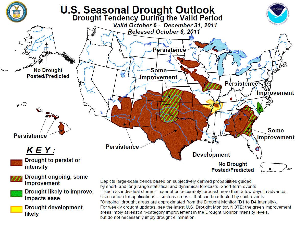
Latest Seasonal Assessment -
The drought outlook for October 6, 2011 – December 2011 was based upon climate anomalies associated with La Niña, short to
medium range forecasts, and climatology. Persistence or development can be expected across much of the Southeast and lower
Mississippi Valley. However, some improvement is forecast across parts of Florida, Georgia, and South Carolina where moderate
to heavy rainfall is forecast early in the period. The return of La Niña elevates the chances for persistence across most of
the exceptional drought areas of the southern Plains. Expected rainfall during early-to-mid October results in a forecast of
some improvement across western Oklahoma and northwest Texas. It should be noted that forecast confidence across the western
Gulf region and Southeast is tempered due to the potential for heavy rainfall associated with tropical cyclone activity during
the fall. The end of the summer monsoon and enhanced odds for below median precipitation during October – December favor
persistence across the Southwest. A relatively dry climatology favors persistence across Iowa, Minnesota, and South Dakota,
while some improvement is forecast across the decreasing drought areas of Illinois and Indiana. Across Hawaii, drought
persistence is forecast for the western Big Island, Molokai, and Maui since the wet signal associated with La Niña typically
becomes established later in the winter.
|
|
Discussion for the Seasonal Drought Outlook
Tools used in the U.S. Drought Outlook (USDO)
included the official CPC temperature and precipitation outlooks for October 2011
and the long lead forecast for October - December 2011, various medium- and short-range forecasts and
models such as the 6-10 day and 8-14 day forecasts, the soil moisture
tools based on the GFS model and the Constructed Analogue on Soil (CAS) moisture, the Climate Forecast
System (CFS) seasonal precipitation forecasts, the four-month Palmer drought termination and amelioration
probabilities, climatology, and initial conditions.
Texas had its driest summer on record, with a
statewide average of 2.44 inches of rain. 2011 was the hottest summer on record for Oklahoma and Texas with average
temperatures of 86.5 degrees F and 86.6 degrees F, respectively. According to the National Climatic Data Center, Texas
recorded the hottest summer for any state. A large area of extreme to exceptional drought continues across the southern
Plains where below normal precipitation has persisted since mid-September. During the second week of October, an upper-level
trough is expected to bring much needed rainfall to western Oklahoma, the Texas Panhandle, and northwest Texas. Since
January 1, Amarillo, Texas has received 3.61 inches of precipitation. The potential exists for 1 to 3 inches of rainfall,
with locally higher amounts, where some improvement is forecast. Across the remainder of Oklahoma and Texas persistence is
based on the OND precipitation outlook calling for enhanced odds of below median precipitation.
Forecast confidence for the southern Plains is moderate.
During the summer, monsoon rainfall provided
drought relief to eastern Arizona and western New Mexico. An early season snowstorm affecting the San Juan mountains of
southwest Colorado at the beginning of October warrants the removal of development forecast in the previous outlook. The end
of the monsoon coupled with forecasts of enhanced odds for below median precipitation during the upcoming three months
favors persistence across Arizona, southeast Colorado, and New Mexico.
Forecast confidence for the Southwest is moderate.
Since mid-September, little or no change has
occurred to the drought areas across the Carolinas, Alabama, Georgia, and Florida where rainfall amounts have generally
averaged near normal. As of October 5, model guidance remains consistent indicating tropical or subtropical low pressure
development in the eastern Gulf of Mexico. Heavy rainfall associated with this system is expected to provide some improvement
to parts of Florida, Georgia, and South Carolina. Outside the expected rainfall from this upcoming low pressure system,
consecutive La Niña composites and the OND precipitation outlook favor persistence across north-central Georgia and eastern
Alabama. Improvement is forecast for southeast North Carolina where the seasonal precipitation outlook indicates equal
chances while the 6-10/8-14 day forecasts indicate enhanced odds for above median rainfall. The October-December climatology
across south Florida trends much drier, with this region receiving only 10-20 percent of their annual rainfall (versus a
normal distribution of 25 percent) during the period. Although rainfall is expected during early-to-mid October with the
aforementioned low pressure system, a drying climatology and current low lake levels leads to a forecast of persistence for
Lake Okeechobee.
Forecast confidence for the Southeast is moderate.
Moderate to exceptional drought continues across
Arkansas, Louisiana, and west Tennessee. Based on back to back La Niña composites indicating a strong signal for dryness in
this region, persistence or development is forecast for the lower Mississippi Valley.
Forecast confidence for the lower Mississippi Valley is high.
Across the upper/middle Mississippi Valley and
Corn Belt, a lack of late summer rainfall resulted in drought expansion. During the past 30 days, little or no rainfall has
occurred across Minnesota, South Dakota, and western Iowa. Since tools on most time scales show weak signals, persistence is
based on the recent dryness and a relatively dry climatology. It should be noted that lake levels are extremely low in
northeast Minnesota, including Basswood Lake. Farther to the east across Illinois and Indiana, rainfall has averaged near to
above normal since mid-September. Although the OND precipitation outlook calls for a slight tilt in the odds for below
median precipitation, some improvement is forecast for the short-term drought areas of Illinois and Indiana related to
cooling temperatures and a wetter climatology compared to areas northwest of this region.
Forecast confidence for the upper/ middle Mississippi Valley and Corn Belt is low.
In Hawaii, drought continues on the western Big
Island, Maui, and Molokai. Although the return of La Niña favors above median precipitation across the Hawaiian Islands, the
wet signal typically occurs later during the winter season. Therefore, persistence is forecast at this time for the ongoing
drought areas.
Forecast confidence for Hawaii is low.
|


