|
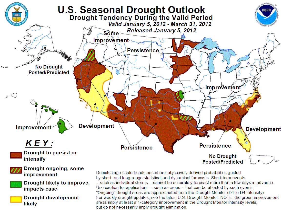
Latest Seasonal Assessment -
The drought outlook for January 5 - March 31, 2012 was based upon climate anomalies associated with La Niña, short to medium
range forecasts, climatology, and initial conditions. Persistence or development can be expected across much of the Southeast
with the highest forecast confidence in Florida. Frequent periods of precipitation improved drought conditions across the
southern Plains during the past two months. However, a return of dry weather and the ongoing La Niña favor persistence across
most of southern Kansas, Oklahoma, and Texas. Despite the early winter snowfall in Arizona and New Mexico, La Niña elevates the
odds for drought persistence across the Southwest. A lack of early winter precipitation resulted in moderate drought
development and expansion of abnormal dryness across southern Oregon, California, and Nevada. Antecedent dryness coupled with
no wet signal among precipitation tools favor persistence across northern California and northwest Nevada, while La Nina favors
development across southern California. Some improvement is forecast in southern Oregon where La Niña tends to bring heavier
precipitation amounts. A relatively dry winter climatology elevates the chances for persistence across the western Corn Belt
and upper Mississippi Valley. Drought improvement is forecast for Hawaii which is consistent with a La Niña winter.
|
|
Tools used in the U.S. Drought Outlook (USDO)
included the official CPC temperature and precipitation outlooks for January 2012
and the long lead forecast for January 2012 - March 2012, various medium- and short-range forecasts and
models such as the 6-10 day and 8-14 day forecasts, the soil moisture
tools based on the GFS model and the Constructed Analogue on Soil (CAS) moisture, the Climate Forecast
System (CFS) seasonal precipitation forecasts, the four-month Palmer drought termination and amelioration
probabilities, climatology, and initial conditions.
Since the La Niña event of 2010-2011, widespread
moderate to extreme drought remains entrenched across much of the Southeast. La Niña conditions returned during fall
2011 and are expected to persist throughout the outlook period. Precipitation tools on most time scales (except for days
6-10) favor below median precipitation across the southern half of Alabama and Georgia along with the coastal Plain of
the Carolinas. Persistence or development can be expected across these areas. March is a relatively wet month across the
mid-South and early spring precipitation plays a critical role in drought severity heading into the warm season.
Forecast confidence for the Carolinas, Georgia, and Alabama is moderate.
Although the rainy season eased drought conditions across the Florida peninsula, the return of La Niña strongly favors
drought development in central and south Florida. Below average water levels (1 foot or more) are observed at Lake
Okeechobee at the beginning of the dry season and probabilities of below median rainfall through the winter are greater
than 60 percent in south Florida. Since the previous outlook, abnormal dryness expanded to cover the nearly the entire
Florida peninsula. Severe to extreme drought continues across parts of the Florida Panhandle which missed the heavier
summer and early fall rainfall. La Niña composites and the CPC January – March outlook indicate a relatively high
probability for below median precipitation across the Florida Panhandle where persistence is forecast.
Forecast confidence for Florida is high.
Due to frequent rainfall during November and December, Arkansas is almost drought-free. Amelioration of drought
conditions occurred in extreme northern Louisiana since mid-December with little or no change to drought status across
the remainder of Louisiana and the Mississippi Gulf Coast. La Niña composites along with the precipitation tools on most
time scales (except for days 6-10) favor persistence across much of the lower Mississippi Valley.
Forecast confidence for the lower Mississippi Valley is high.
Across the southern Plains, the most notable drought improvement since mid-December occurred across southern Kansas,
northeast Texas, and the Texas Panhandle. During the past 30 days, precipitation anomalies of 1 to 3 inches were observed
in northeast Texas, while heavy snow blanketed the Texas Panhandle during late December. Following the beneficial
precipitation during November and December, dry weather has returned to the southern Plains. La Niña composites along
with precipitation tools on most time scales (except for days 6-10) favor persistence across much of the southern Plains.
However, some improvement or improvement is forecast across southeast Kansas and the Arklatex region where the CPC
seasonal outlook indicates equal chances for below, near, or above precipitation and the 6-10 day outlook indicates
enhanced odds for above median precipitation.
Forecast confidence for the southern high Plains is high and moderate for southeast Kansas, eastern Oklahoma, and
eastern Texas.
From mid-November into December, shortwave troughs digging into the desert Southwest have resulted in widespread moderate
to heavy snow across the higher elevations of Arizona and New Mexico. As of January 1, basin average snow water content
values are running above average across the mountains of Arizona and New Mexico. According to the U.S. Drought Monitor,
the most pronounced improvement in drought conditions has occurred in New Mexico since mid-December. Despite the early
winter snowfall across Arizona and New Mexico, precipitation tools on all time scales favor below median precipitation
which is typical for a La Niña winter. Therefore, drought persistence is forecast across the Southwest.
Forecast confidence for the Southwest is moderate.
A lack of early winter snowfall resulted in the introduction of moderate drought conditions to southern Oregon, northern
California, and northwest Nevada and an expansion of abnormal dryness across the Great Basin. During the past 30 days,
negative precipitation anomalies of more than 6 inches are common across northern California. As of January 1, snow water
equivalent values are running less than 25 percent of average in the Sierras and 25 to 49 percent of average in the
southern Cascades. No measurable precipitation was recorded at Reno, Nevada during December for the first time since
1883. It should be noted that reservoir levels have not suffered yet due to the wet 2010-11 winter. From southern Oregon
southward to California, the unseasonably dry pattern is expected to continue into the second week of January. The
antecedent dryness and no apparent signal for wetness among the various precipitation tools favor persistence across
northern California and northwest Nevada. Across the remainder of California and the Great Basin, drought development is
based on La Niña composites and the CPC seasonal precipitation outlook that indicates a tilt in the odds towards below
median precipitation. Meanwhile, across parts of southern Oregon, some improvement is forecast as the CPC seasonal
precipitation outlook indicates a slight tilt in the odds towards above median precipitation in this region.
Forecast confidence for California and the Great Basin is moderate.
Drought coverage and intensity has remained nearly steady across the western Corn Belt and upper Mississippi Valley since
the previous outlook of December 15. The CPC January and January-March outlooks indicate equal chances for below, near,
or above median precipitation. A dry climatology limits prospects for significant drought relief. Furthermore, since the
ground and streams in this region freeze over during the winter months, it is likely that the benefits of improved
moisture would not be realized until the spring thaw, which occurs at the end of this outlook period. Therefore,
persistence is favored across the western Corn Belt and upper Mississippi Valley.
Forecast confidence for the western Corn Belt and upper Midwest is moderate.
Drought redeveloped during the summer months across the western portions of Hawaii, but recent rainfall reduced
drought coverage across Kauai and Oahu. During a La Niña winter, wetter than average conditions are typically observed,
particularly after January. Based on these climate anomalies, drought improvement is forecasted for the leeward sides of
the Hawaiian Islands.
Forecast confidence for the Hawaii is moderate.
|


