|
Latest Seasonal Assessment -
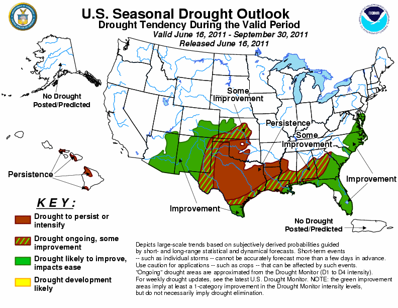
ENSO-neutral conditions developed during the first part of June, but in the wake of the 2010-2011 La Nina, widespread
drought developed and persisted across the southern tier of the U.S. Significantly, nearly 60 percent of the current
drought areas are extreme or exceptional, with many areas experiencing record precipitation deficits. During the
previous two weeks, exceptional drought continued to expand across the southern Rockies, south-central Plains, and
portions of the Southeast. The summer onset of the rainy season in Florida has been delayed, exacerbating the long
standing drought and contributing to outbreaks of wildfires, while the North American Monsoon has also seen a
sluggish start, where Arizona is currently battling the largest wildfire in state history. Due to the expected onset
of the rainy season in Florida and monsoon thunderstorms across the Southwest, drought improvement is expected during
the upcoming three months. Enhanced chances of above-median rainfall across the southern Atlantic states also favors
drought amelioration. In contrast, a dry climatology and above-median temperatures expected during the summer months
across the southern Plains limits opportunities for drought reduction. Across the remainder of the Southeast, some
improvement is possible under a summertime convective regime, although rainfall deficits are substantial and long-term
in some areas, particularly across Louisiana. The prospect of tropical cyclones, with an expected above-normal season
peaking in September, adds to the forecast uncertainty. Across Hawaii, leeward drought persistence is expected under
the summer trade wind regime.
|
|
Tools used in the U.S. Drought Outlook (USDO)
included the official CPC temperature and precipitation outlooks for July 2011 and the long lead forecast for
July - September 2011, various medium- and short-range forecasts and
models such as the 6-10 day and 8-14 day forecasts, the soil moisture
tools based on the GFS model and the Constructed Analogue on Soil (CAS) moisture, the Climate Forecast
System (CFS) seasonal precipitation forecasts, the four-month Palmer drought termination and amelioration
probabilities, climatology, and initial conditions.
Drought expanded and intensified
across the southern Plains during the previous 30 days, as many locations received much below average rainfall
during the climatologically wet month of May. In Texas as of June 7, drought conditions covered just over 98
percent of the state's land mass, with exceptional drought (U.S. Drought Monitor D4 category) blanketing
nearly 60 percent of the state. Drier weather is typical across the eastern half of Texas and the lower
Mississippi Valley during July and August, with mean precipitation increasing substantially in September
across southern Texas. The climatologically drier summer pattern limits opportunities for substantial drought
reduction across Texas, Oklahoma, and the Mississippi Delta region, while increased rains in September boost
chances of drought improvement for southern Texas. Summertime convection and the potential for tropical
cyclone activity may ameliorate some of the drought closer to the western Gulf coast. The CPC July outlook
calls for enhanced odds of below-median precipitation and above-median temperatures across the southern Plains,
supporting continued drought persistence. Therefore, persistence is indicated across central and northeastern
Texas, central Oklahoma, and northern Louisiana, while some improvement or improvement are expected across far
southern Texas and the western Gulf Coast.
Forecast confidence for the southern Plains and Mississippi Delta is moderate.
Mostly dry weather prevailed across
the far southwestern United States during the previous 30 days, allowing drought areas to persist or intensify.
As of June 7, exceptional drought covered nearly 45 percent of New Mexico, including nearly all of the state's
southern half. Exceptional drought expanded into the far eastern portions of neighboring Arizona, where the
Wallow wildlands fire has burned nearly 470,000 acres and currently stands as the largest wildfire in state
history. During June and July, the North American Monsoon shifts northward from Mexico's Sierra Madres into
the southwestern United States, bringing scattered showers and thunderstorms which account for a significant
portion of the annual rainfall. The monsoon typically peaks in July and August before decaying in September.
Currently, the northward progression of the monsoon through northwestern Mexico has been delayed, while models
such as the CFS and analog techniques have provided conflicting forecasts of the monsoon's strength. The CPC
July outlook calls for enhanced odds of below-median precipitation across western Texas and eastern New Mexico,
the eastern flank of the monsoon region, while the July - September seasonal outlook maintains equal chances.
This outlook, therefore, favors climatology, with the North American monsoon bringing drought improvement to
Arizona, western New Mexico, and portions of Colorado and northwestern Kansas. Note that drought improvement
as defined in this outlook verifies as a one-category reduction on the U.S. Drought Monitor, rather than total
drought elimination or substantial amelioration of impacts. Improvement is less certain across eastern New
Mexico and the Texas Panhandle region, where forecasts are drier and drought is more entrenched.
Forecast confidence for the southwestern United States is low to moderate.
Much below average rainfall was
observed across the Deep South and southern Atlantic coastal Plain during the previous 30 days, allowing
drought conditions to expand and intensify. A region of exceptional drought has developed from the lower
Chattahoochee River basin southeastward into the Okefenokee Swamp region. Scattered showers and thunderstorms
typically occur across the Southeast during the summer months, with the southern Atlantic coastline receiving
30 to 40 percent of its annual rainfall during the July - September period. Tropical cyclones or their
remnants can also bring substantial rainfall to the Southeast during the summer or early autumn months. The
CPC July - September seasonal outlook calls for increased odds of above-median rainfall across the southeastern
coastal Plain and piedmont regions. Since these improved rainfall chances occur during a climatologically wet
time of year for the Southeast, improvement is indicated in this outlook from the eastern Gulf Coast through
the Delmarva Peninsula. Some improvement is maintained across the remainder of the Deep South.
Forecast confidence for the Southeast and southern Atlantic is high.
The Florida peninsula's seabreeze
convergence driven rainy season, which typically begins in late May, has been delayed, leading to a substantial
deterioration of long-standing drought conditions across southern Florida and increasing wildfires. In Fort
Lauderdale, FL, the total observed precipitation from October 1, 2010 through June 9, 2011 was 9.32 inches,
which is 25.94 inches below normal. Exceptional drought conditions currently cover much of southeastern
Florida from Martin County through northern Miami-Dade County. The southern half of the Florida peninsula
typically receives 40 to 45 percent of its annual rainfall during the July - September period, and the CPC
July - September seasonal outlook indicates enhanced odds of above-median precipitation. Therefore, once the
rainy season commences and persists, drought improvement is likely. The Florida peninsula is also prone to
tropical cyclone landfalls, which can bring substantial rainfall in short periods of time. The climatological
peak of hurricane season falls in early September.
Forecast confidence for the Florida peninsula is high.
In Hawaii, the CPC July - September
seasonal outlook indicates enhanced chances of below-median rainfall. This, coupled with the summer trade
wind regime, which favors dryness on the lee sides of the islands, favors persistence of the existing drought
areas in the state.
Forecast confidence for Hawaii is moderate.
|


