|
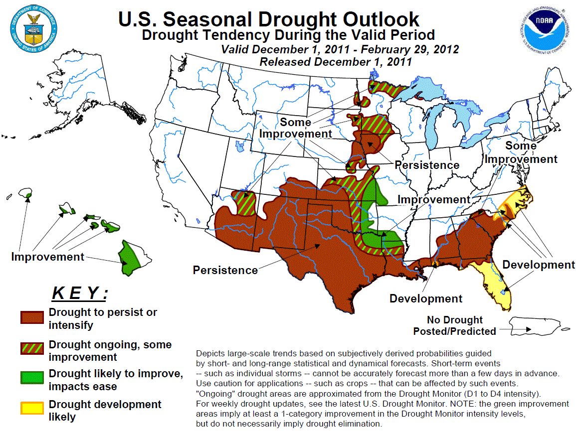
Latest Seasonal Assessment -
La Niña conditions developed during the northern hemisphere fall for a second year in a row, with below average equatorial
Pacific sea surface temperatures expected to persist through the 2011-2012 winter season. Therefore, climate anomalies
associated with La Niña winters were closely considered both for the U.S. Drought Outlook and the CPC monthly and seasonal
guidance. During the previous two weeks, widespread rainfall further eased lingering drought conditions across the lower
Mississippi Valley and southeastern Plains in a continuation of a wet autumn pattern. Short term forecasts indicate new
rounds of heavy rainfall in early December, which will likely bring additional improvement from southeastern Kansas through
northern Louisiana. An early December winter storm might also bring some early mountain snowfall to the Southwest, though
overall below median precipitation is expected during the winter season. Ongoing drought conditions elsewhere across the
southern tier of U.S. states are expected to persist or worsen, however, with drought development likely across the Florida
Peninsula. Drought development is also possible across eastern North Carolina, where the CPC seasonal outlook indicates
enhanced odds of below median precipitation. While La Niña winters favor a wetter pattern across the northern U.S., a
combination of recent excessive dryness across portions of the western Corn Belt, a drier winter climatology, and frozen soil
and streams reduce the prospects for significant improvement of drought impacts in the upper Midwest and Great Lakes.
|
|
Discussion for the Seasonal Drought Outlook
Tools used in the U.S. Drought Outlook (USDO)
included the official CPC temperature and precipitation outlooks for December 2011
and the long lead forecast for December 2011 - February 2012, various medium- and short-range forecasts and
models such as the 6-10 day and 8-14 day forecasts, the soil moisture
tools based on the GFS model and the Constructed Analogue on Soil (CAS) moisture, the Climate Forecast
System (CFS) seasonal precipitation forecasts, the four-month Palmer drought termination and amelioration
probabilities, climatology, and initial conditions.
Following the La Niña event of 2010-2011, widespread drought remains entrenched across much of the southern U.S. states.
While the rainy season eased drought across the Florida Peninsula, and repeated bouts of locally heavy autumn rainfall
eroded drought conditions along the lower Mississippi River Valley, abnormal dryness persisted across parts of the Southeast
and southern Texas. La Niña conditions re-emerged during Fall 2011, and CPC projects that these conditions will continue to
persist through the northern hemisphere winter season. Therefore, the CPC December-February outlook favors below median
precipitation across the south central and southern tier of the U.S., particularly in Florida, Texas, and southern New
Mexico. The updated CPC December outlook also tilts the odds towards below median precipitation across southern Texas,
the Gulf Coast, and the southern Atlantic coastal Plain. Based on these forecasts, drought persistence or intensification
is expected across much of Texas, the Gulf Coast, and throughout the Southeast. Drought development is likely across the
Florida peninsula, where below average water levels were observed in Lake Okeechobee heading into the dry season and
probabilities of below median rainfall through the winter are greater than 60 percent. Drought development is also possible
in eastern North Carolina, where autumn rainfall in many locations ranged from 50 to 70 percent of normal.
Forecast confidence for the Southeast, Gulf Coast, and south central U.S. is high.
During the previous several weeks, a persistent pattern of troughs digging into the central U.S. brought several periods of
locally heavy rainfall to the southern Mississippi Valley, easing drought conditions primarily across Arkansas and eastern
Oklahoma. 30 day rainfall totals are well above average across nearly all of Oklahoma and Arkansas, and are near normal
across northern Louisiana. During early December, a potent trough is expected to dig southward into the west central U.S.,
bringing another round of significant rainfall to the southeastern Plains and the Mississippi and Ohio River Valleys. The
area of heaviest rainfall is expected to extend as far west as northeastern Texas. Additionally, a similar pattern during
the second week of December, based on CPC's 6-10 and 8-14 day outlooks enhances the odds for additional rainfall following
this early December event. Based on the prospects for significant rainfall in the short term, improvement is expected
across a swath from southeastern Kansas through far northern Louisiana, areas bordering regions which have recently
experienced drought relief. Although the CPC winter outlook maintains enhanced chances for below median precipitation in
this region, the short and extended range pattern is noted in the updated CPC December outlook, which tilts the odds
towards above-median rainfall from northern Texas and Louisiana through southeastern Kansas. The prospects for significant
improvement drop quickly further west into central Texas and the Great Plains.
Forecast confidence for eastern Kansas southward through northern Louisiana is moderate.
Drought conditions continued to expand across the western Corn Belt and upper Midwest during the previous two weeks. 90 day
precipitation deficits below 50 percent of normal extend from eastern Nebraska and the Dakotas through much of Minnesota.
The CPC 6-10 and 8-14 day forecasts place increased odds of enhanced precipitation across the upper Midwest, but
precipitation amounts are unlikely to erode the long term deficits. The December outlook maintains equal chances across the
area, while the CPC winter outlook, based on the La Ni&mtilde;a conditions, favors greater chances of above median precipitation.
Even if the upper Midwest receives above average snowfall during the winter months, the dry climatology limits prospects for
significant drought relief. Furthermore, since the ground and streams in this region freeze over during the winter months,
it is likely that the benefits of improved moisture would not be realized until the spring thaw, which occurs after this
outlook period ends. Therefore, some improvement is indicated for most of the upper Midwest and Corn Belt's drought areas,
in deference to the seasonal outlook, while persistence is forecasted for northeastern Nebraska and northwestern Iowa, which
are mostly south of the seasonal outlook's 33 percent contour and have some of the largest moisture deficits in the region.
Forecast confidence for the western Corn Belt and upper Midwest is moderate.
Abnormal dryness is typical across the Southwest during a La Niña winter, and this climate anomaly is indicated in the CPC
winter outlook, which tilts the odds towards below median precipitation across interior southern California, Arizona, and
New Mexico during December through February. Short term forecasts, however, indicate the potential for a potent winter
storm to impact the southwestern U.S. during early December, with some models indicating a slow progression of the system,
which could bring locally heavy mountain snowfall. Based on this forecast, the areas of development in the Southwest placed
on the November 17 USDO for the winter season have been removed. Also, some improvement instead of persistence is forecast
for northeastern Arizona, where autumn rainfall was above average. Beyond the short term, below median precipitation is
still expected for the remainder of the winter season, so the persistence forecast is maintained across the remainder of the
Southwest.
Forecast confidence for the Southwest is moderate.
Drought redeveloped during the summer months across the western portions of the Hawaii. During a La Niña winter, wetter
than average conditions are typically observed, particularly after January. Based on these climate anomalies, drought
improvement is forecasted for the leeward sides of the Hawaiian Islands.
Forecast confidence for the Hawaii is low to moderate.
|


