|
Tools used in the U.S. Drought Outlook (USDO)
included the official CPC precipitation outlook for September 2010 and the long lead forecast for
September - November 2010, various medium- and short-range forecasts and
models such as the 6-10 day and 8-14 day forecasts, the soil moisture
tools based on the GFS model and the Constructed Analogue on Soil (CAS) moisture, the Climate Forecast
System (CFS) seasonal precipitation forecasts, La Niña composites for the September - November season, the four-month Palmer
drought termination and amelioration probabilities, climatology, and initial conditions.
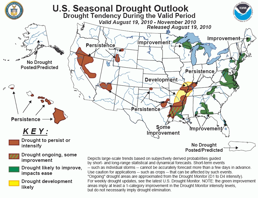
Moderate drought has developed recently across
parts of northern Pennsylvania northeastward into New England as 30-day streamflows are below-average and regional
precipitation coverage during the summer has been irregular. Forecasts show some potential for rain in the region through
the upcoming week. However, CPC's 6-10 and 8-14 day precipitation forecasts show below-median precipitation probabilities in
the region, and the monthly and seasonal forecasts show equal chances for above or below-median precipitation. There is a
climatological increase in precipitation in this region during the months of fall, which would lend itself to improvement.
Despite the longer-range forecasts, improvement is forecast across this region based on climatology and potential for
short-term rains.
Forecast confidence for the Northeast is low.
Above-average temperatures in July and early
August combined with suppressed summertime thunderstorm coverage has led to expanding drought across the mid-Atlantic and
in parts of the southeast. Recent rains have resulted in some improvement to conditions in parts of Maryland, Georgia and
Alabama. Five-day precipitation forecasts show a continued wet pattern for much of the mid-Atlantic and the southeast.
Medium to long-range forecasts show a slight tilt in the odds toward above-median precipitation in the southeast, with
near-median or equal chances forecast for the mid-Atlantic. The potential for tropical cyclone activity also favors
improvement in the mid-Atlantic and the southeast. Beyond this season, prospects for improvement are likely to be minimal in
the winter months as La Niña conditions favor increasing dryness across the southeast.
Forecast confidence for the mid-Atlantic and the southeast is moderate.
In the upper Mississippi Valley and Great Lakes,
long-term drought has diminished in severity and in areal coverage due to the effects of several rainfall episodes that have
taken place this summer. Short-term (0-5day) and medium-range (6-10 and 8-14 day) forecasts favor wetness continuing across
this region. The monthly and seasonal precipitation forecasts show equal chances for above-median or below-median
precipitation in this region. Continued improvement is forecast given the prospects for precipitation in the short to
medium-range. Despite the expected improvement, hydrological impacts associated with this protracted drought are likely to
persist.
Forecast confidence for the upper Mississippi Valley and Great Lakes region is moderate.
A substantial mid-to-late July heat wave combined
with spotty rainfall has resulted in expansion of drought from the mid-Mississippi and lower Ohio Valley southward into
southern Arkansas. Short-range forecasts suggest isolated precipitation is likely to continue. Several of CPC's medium to
extended-range forecasts, including the 6-10 and 8-14 day and the monthly and seasonal forecasts favor above-average
temperatures and below-median precipitation across this region. In addition, La Niña composites for the September - November
season show a signal for below-median precipitation. Several of the soil moisture forecasts show mixed signals. The expected
isolated nature of precipitation in the short-term combined with CPC's medium-to-extended range forecasts lead to a forecast
of drought persistence in areas where D1 or greater drought currently exists, and drought development in central and eastern
Arkansas, southeastern Missouri and western Tennessee.
Forecast confidence for the mid-Mississippi, lower Ohio Valley and southern Arkansas is low to moderate.
Ongoing drought continues across northern and
central Louisiana, where drought severity in Louisiana ranges from D0/D1 in central Louisiana to D2/D3 in northern Louisiana.
Heavy rainfall over the past five days from the remnants of Tropical Depression #5 has led to some reduction in drought over
central Louisiana. Additional short-term rainfall is likely to continue across northern and central Louisiana, though
forecast totals are expected to decrease with northward extent. CPC's 6-10 day, 8-14 day, monthly and seasonal forecasts
favor above-median precipitation for central and southern Louisiana. In northern Louisiana, monthly and seasonal forecasts
show equal chances for below or above-median precipitation, and the 6-10/8-14 day forecasts favor near to below-median
precipitation. Improvement is forecast in much of the south-central Louisiana D1 area, where expected short-term rains and
favorable long-range forecasts are likely to fall in areas where drought is less severe. In northern Louisiana, decreasing
short-range precipitation totals combined with more pessimistc longer-range forecasts suggest conditions may improve but a
1-category amelioration in drought is not likely. Tropical cyclone activity adds some uncertainty to the forecast,
particularly early in the seasonal period when tropical cyclones are climatologically more frequent. If a tropical cyclone
were to make landfall in the central Gulf Coast region, improvement would be more likely in northern Louisiana.
Forecast confidence for Louisiana is moderate.
Small areas of moderate to severe drought exist in
parts of Oklahoma and northern Texas. An extension of the subtropical ridge has contributed to above-average temperatures
and suppressed thunderstorm coverage in the southern Plains. Forecasts show these conditions continuing through the Week-2
period, and there are no indications of drought improvement from any of the monthly or seasonal forecasts across the southern
Plains as well. Based on these forecasts, drought persistence is indicated.
Forecast confidence for the southern Plains is moderate.
An increase in late-spring precipitation in the
Northern Rockies and the Great Basin resulted in beneficial drought improvement. Small areas of moderate to severe drought
remain across the Northern Rockies, while an area of D1/D2 drought continues in the Great Basin. Climatological dry
conditions and monthly and seasonal precipitation and streamflow forecasts favoring dryness lead to a forecast of drought
persistence.
Forecast confidence for the Great Basin and the Northern Rockies is high.
Since mid-July, an active monsoon circulation has
resulted in improvement in drought conditions across the Southwest, although an area of D1/D2 drought has persisted across
northern Arizona. Additional monsoon rains are possible in parts of this region through the remainder of August, as is
indicated in CPC's 6-10 and 8-14 day forecasts showing slightly greater probabilities for above-median precipitation.
However, beneficial rains are expected to become less likely as the North American Monsoon climatologically ends in
September. CPC's long-range forecasts also show a tilt in the odds toward dry conditions. Thus, drought persistence is
forecast for the Southwest.
Forecast confidence for the Southwest is moderate.
Moderate to exceptional drought (D1 to D4
designations) continues across the leeward sides of the Hawaiian Islands. Forecasts for these areas call for below-median
rainfall during September - November, leading to a forecast of drought persistence. Precipitation does show a climatological
increase later in fall, and La Niña conditions would tend to favor above-average precipitation during the winter months. This
suggests drought improvement could become more likely beyond this forecast period.
Forecast confidence for Hawaii is high.
|


