|
Latest Seasonal Assessment -
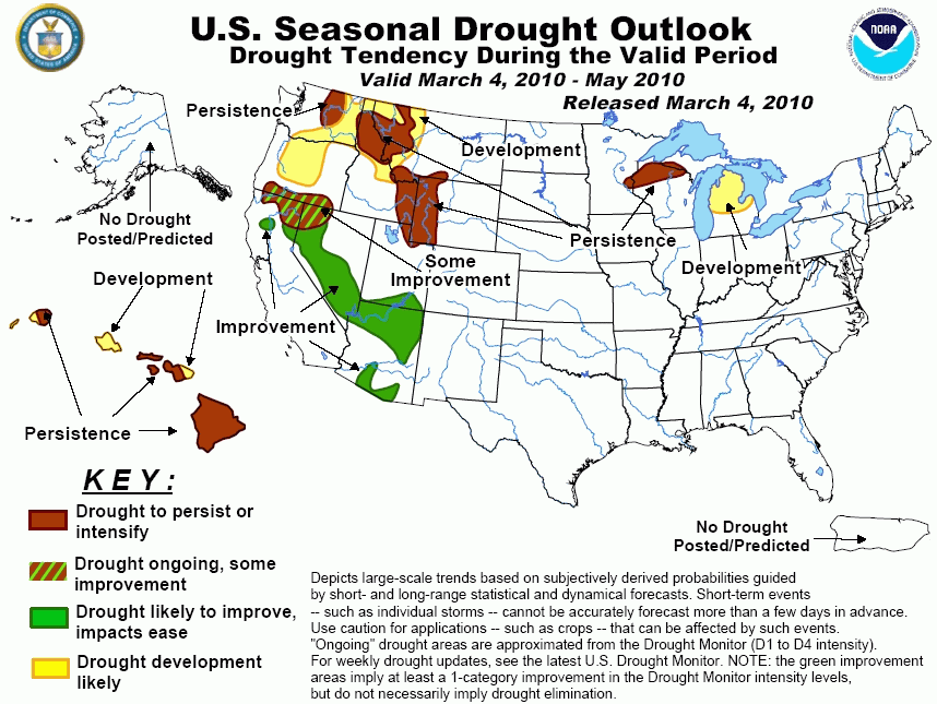
An active, stormy pattern continues to bring significant precipitation to most of California and the Southwest, slowly easing
the drought in these areas, and more improvement is predicted. More limited relief is anticipated across southern Oregon and
nearby parts of Nevada and California. In the interior Pacific Northwest and northern Rockies, the situation is somewhat less
clear. Drought is likely to persist over central Washington and the northern Rockies, with the predicted onset of drought
indicated over nearby areas. However, with a number of forecasting tools giving mixed signals, it was deemed premature to
introduce drought over eastern Oregon at this time. In the Great Lakes region, moderate to severe drought is expected to persist
across northwest Wisconsin, while developing drought is indicated for much of lower Michigan. This latter area experienced one
of its driest January-February periods on record, and many tools are indicating this dry trend will continue well into the
spring.
|
|
Tools used in the Drought Outlook
included the official CPC precipitation outlook for March 2010 and the long lead forecast for
March - May 2010, the four-month Palmer drought termination and amelioration probabilities, various
medium- and short-range forecasts and models such as the 6-10 day and 8-14 day forecasts, the
soil moisture tools based on the GFS model and the Constructed Analogue on Soil (CAS) moisture, the Climate
Forecast System (CFS) seasonal precipitation forecasts, El Niño precipitation and
temperature composites for March - May 2010, climatology, and initial conditions.
Moderate to severe drought continues in northwest
Wisconsin. The persistent drought in this area has lasted for at least 18 months, and any rain/snow that has fallen during
this period has not been enough to overcome long-term deficits. Official CPC mean precipitation forecasts out through the
March-May 2010 season mostly call for enhanced chances of below-median precipitation, with the exception of above-median
precipitation anticipated in the 6-10 day period. CAS and CFS precipitation forecasts for the M-A-M season favor persistence
of dryness across this region, though the CFS monthly forecast for May 2010 indicates near-median conditions. In northwestern
Ohio, and central and northern lower Michigan, significant negative precipitation departures (2 to 4 inches) have been
observed over the past 60 days. Seasonal snowfall-to-date has been well below normal for many areas in northern lower
Michigan. For example, Gaylord has received 78.5 inches of snow so far this season, well short of its 134.3 inches typically
received by this date. During the past 28 days, average stream flows in this area rank within the driest historical quartile,
though there has been more recent improvement due to snowmelt and more precipitation. For the MAM season, drought is expected
to develop especially over lower Michigan.
Forecast confidence for Wisconsin and lower Michigan is low to moderate.
During the past 1-2 weeks, a wet pattern has
generally prevailed across California and the interior Southwest. Precipitation and stream flows are either near or above
normal, though there are localized exceptions. One of these exceptions is far northeastern California and adjoining
northwestern Nevada, where very little relief has occurred. The Outlook for the Southwest shows continued improvement,
consistent with CPC's long-range outlooks, and also with El Ni&ntile;o composites for late winter and much of spring 2010.
Forecast confidence for the Southwest is moderate.
In the interior Pacific Northwest and northern
Rockies, relatively dry weather has prevailed for much of the winter, largely because of the southward displaced storm track
and jet stream, which is common during El Niño winters. In addition, snow pack is running below normal in many areas, which
means less recharging of both soils and streams during the upcoming spring, and related water supply issues. However, GFS
soil moisture change forecasts for the ensuing two weeks, and the most recent CAS precipitation forecast for MAM 2010
suggest a tilt in the odds away from developing drought for eastern Oregon. The CPC monthly and seasonal precipitation
outlooks also back off on the possibility of developing drought for the eastern portions of Oregon, and keep the highest
likelihood for drought or dryness over northwest Oregon and especially Washington state.
Forecast confidence for the interior Pacific Northwest and northern Rockies is low to moderate.
As is consistent with an ongoing El Niño, Hawaii
is expected to receive below-median precipitation during this period. These dry conditions will likely exacerbate ongoing
areas of severe to extreme drought over Hawaii and also provide support for drought development over the remainder of the
island chain.
Forecast confidence for Hawaii is high.
|


