|
Tools used in the U.S. Drought Outlook (USDO)
included the official CPC precipitation outlook for January 2011 and the long lead forecast for
January - March 2011, various medium- and short-range forecasts and models such as the 6-10 day and 8-14 day forecasts, the soil moisture
tools based on the GFS model and the Constructed Analogue on Soil (CAS) moisture, the Climate Forecast
System (CFS) seasonal precipitation forecasts, La Niña composites for the December - February season, the four-month
Palmer drought termination and amelioration probabilities, climatology, and initial conditions.
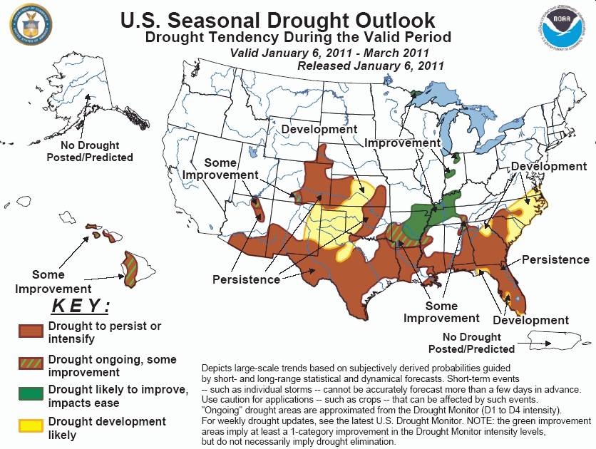
Areas of heavy rainfall overspread
portions of the immediate Gulf Coast, with the heaviest totals, exceeding 4 inches, observed along the
northern coastline of Texas. Above average rainfall also fell along a line from central Mississippi through
eastern Tennessee, generally outside of the core drought areas of the Southeast. Elsewhere, however, below
average rainfall persisted, particularly in Florida, Georgia, and northern Louisiana. Short term forecasts
indicate the potential for widespread rainfall across the Southeast, with accumulations generally between
1 and 2 inches in most locations. The CPC 6-10 and 8-14 day outlooks indicate near median rainfall, and the
monthly and seasonal outlooks both favor below median precipitation, particularly across Florida. While the
short term rainfall may slow additional drought expansion, strong dry climate anomalies associated with La
Niña promote persistence of existing drought, with further drought development most likely in Florida and
along the southern Atlantic coastline. The forecast becomes more complicated from the southern Appalachians
through far southeastern Oklahoma, as a tight anomaly gradient exists between the Southeast and the Tennessee
and Ohio Valleys, where above median precipitation is favored. While the presence of a strong La Niña tends
to expand the dry anomalies northward, intraseasonal factors such as the Arctic Oscillation, which is
currently in a negative phase, can counteract the northward expansion of the dry anomaly. For this outlook,
a boundary of some improvement between drought persistence to the south and improvement to the north runs
from southern Arkansas through Tennessee's border with Alabama and Georgia.
Forecast confidence for the Southeast is high for the coastal plain, and low from southern Arkansas
through the southern Appalachians.
A second winter storm generated
additional snowfall across the northern Plains and upper Midwest following the major winter storm in early
December. Snow depths across the small remaining drought area of extreme northeastern Minnesota remain near
20 inches, with liquid equivalents between 3 and 6 inches. Due to the already extensive snowpack, further
drought improvement in this region is likely.
Forecast confidence for northeastern Minnesota is high.
Near average precipitation, falling
as both snow and rain, overspread the drought areas of the middle Mississippi Valley and Indiana during the
previous two weeks, with no remaining snowpack. CPC 6-10 and 8-14 day outlooks, however, indicate enhanced
odds of above median precipitation. Based on pronounced climate anomalies associated with La Niña, the CPC
monthly and seasonal outlooks both favor enhanced above median precipitation probabilities as well. Storm
tracks during a La Niña winter strongly favor the Ohio Valley region, particularly during the January-March
period. Based on the favorable seasonal outlook, further drought amelioration is forecasted from
northeastern Arkansas through Indiana.
Forecast confidence for the middle Mississippi and Ohio Valleys is high.
Outside of a band of above average
precipitation extending from northern Texas through southeastern Oklahoma, widespread dry weather persisted
across the central and southern Plains. Drought conditions expanded or intensified across western Texas,
Oklahoma, and Kansas. Short term forecasts indicate a potential for snowfall across portions of the northern
and central Plains as an Arctic air mass pushes southward out of Canada. Portions of northwestern Kansas
may receive more than 0.5 inch liquid equivalent of snow, but little precipitation is expected to push into
the southern High Plains. The CPC 6-10 and 8-14 day forecasts favor dry conditions across Texas, and the
seasonal outlook indicates enhanced odds of below median precipitation across the southern High Plains.
Based on these outlooks, drought persistence is expected, with additional drought development possible across
northern Texas and central Kansas.
Forecast confidence for the central and southern Plains is moderate.
A series of massive winter storms
brought much above average precipitation to California, Nevada, northwestern New Mexico, and the central
Rockies during the previous two weeks. Lingering drought conditions eased across the Great Basin,
northeastern California, and Wyoming. Further south, little precipitation fell across drought areas in far
southern Arizona and southern New Mexico, where drought conditions continued to expand. While the revised
CPC monthly outlook for January reflects greater odds for above median precipitation across the southwestern
U.S., short and medium range forecasts indicate a return to near or below average precipitation. The
seasonal outlook indicates greater odds for below median precipitation and above median temperatures across
the southern Four Corners states. Based on these forecasts, which reflect climate anomalies observed during
La Niña winters, drought persistence is maintained in this outlook, with small areas of some improvement
across northern Arizona and south central Colorado, which received significant precipitation during the
previous two weeks.
Forecast confidence for the southwestern U.S. is moderate to high.
Recent early season rainfall
improved drought conditions across the western Hawaiian islands. During a La Niña winter, climate anomalies
favor enhanced precipitation across Hawaii, but not with a high frequency of occurrence. As the rains pick
up in the January-March period, the possibility for drought improvement increases, but significant
improvement is more uncertain, since drought conditions are entrenched. Some improvement is indicated in
this outlook.
|


