|
Latest Seasonal Assessment -
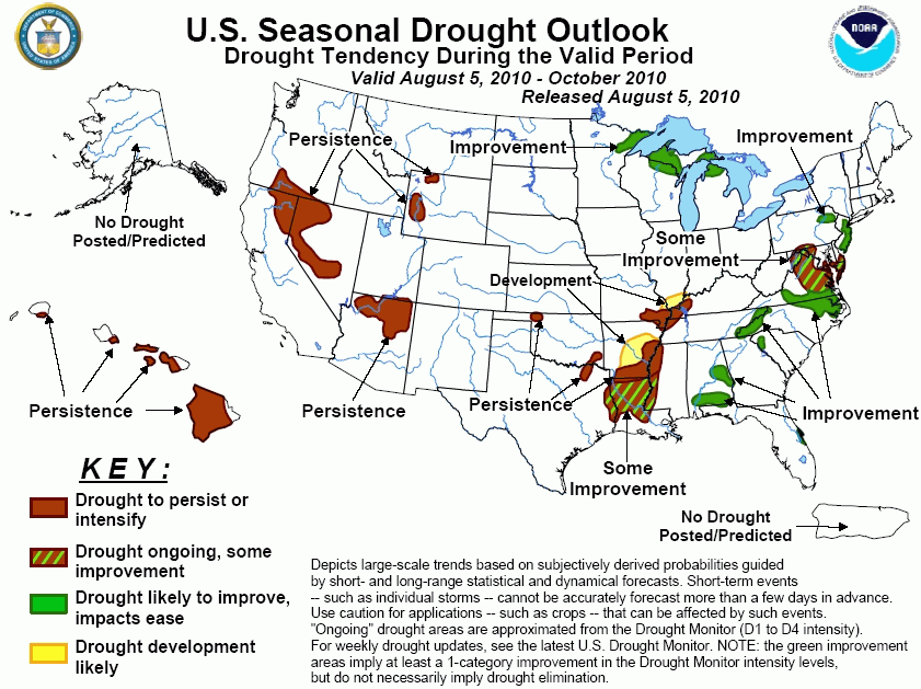
The most significant changes to the previous outlook issued on July 15 include the removal of drought
development in Arizona and a more pessimistic outlook in the lower Mississippi Valley and lower Ohio Valley. Due
to a very active monsoon during the past two weeks, drought was eliminated in New Mexico. However, a slight
expansion of drought has occurred in northwest Arizona. Drought is forecast to persist in Arizona. An ongoing
heat wave coupled with below normal rainfall has resulted in drought intensification and development for parts
of the lower Mississippi Valley and lower Ohio Valley. Drought is expected to persist and expand in the lower
Ohio Valley, southeast Missouri, and parts of Arkansas. Some improvement is forecast in Louisiana where tools
offer higher odds for above median rainfall at most time scales. Although drought has expanded across parts of
the eastern U.S., the outlook calls for improvement or some improvement in this region. Major drought relief has
occurred in the upper Mississippi Valley and Great Lakes region where additional improvement is forecast. A dry
climatology favors drought persistence across western Wyoming, northeast California, Nevada, and the leeward
sides of the Hawaiian Islands.
|
|
Tools used in the U.S. Drought Outlook (USDO)
included the official CPC precipitation outlook for August 2010 and the long lead forecast for
August - October 2010, various medium- and short-range forecasts and models such as the 6-10 day and 8-14 day
forecasts, the soil moisture tools based on the GFS model and the Constructed Analogue on Soil (CAS) moisture, the Climate Forecast
System (CFS) seasonal precipitation forecasts, climatology, and initial conditions.
During the past two months,
substantial drought relief has occurred across the upper Mississippi Valley and Great Lakes region where
extreme drought (D3 according to the USDM) has been reduced to moderate (D1)– severe drought (D2) levels.
Marquette, Michigan measured 5.15 inches of rainfall in July which is the 4th wettest July on record. The
short and median range forecasts are mixed on whether the wet pattern will continue. In the longer ranges,
such as the 30- and 90-day periods, the odds favor neither abnormally wet nor dry conditions. With a
relatively wet climatology early in the outlook period, continued improvement is forecast. Despite the
expected improvement, hydrological impacts associated with this protracted drought may persist.
Forecast confidence for the upper Mississippi Valley and Great Lakes region is moderate.
Hot temperatures combined with a
lack of rainfall have resulted in worsening drought conditions in the lower Mississippi Valley and lower
Ohio Valley. Although severe drought has ended in southeast Oklahoma, a small area of moderate drought
resides in southeast Oklahoma and northeast Texas. A major heat wave is currently affecting this region with
maximum temperatures exceeding 100 degrees F. The CPC precipitation outlook for August indicates a slight
tilt in the odds for above median precipitation in Texas and southern Louisiana, to the west and south of the
core drought areas. The CPC seasonal outlook calls for enhanced odds for above median rainfall in the
southern half of Louisiana. Some improvement is forecast in Louisiana. Farther to the north, a combination of
expected heat and dryness during the next 2 weeks and a lack of a wet signal in the long range forecasts
favor persistence and development in southeast Oklahoma, Arkansas, southeast Missouri, and the lower Ohio
Valley.
Forecast confidence for the lower Mississippi Valley, lower Ohio Valley, and southeast Oklahoma is low.
Hot temperatures and irregular
rainfall have led to the expansion of moderate to severe drought across parts of the eastern U.S. The largest
drought area exists in the mid-Atlantic. Richmond, VA recorded its warmest and 4th driest July. Soil moisture
levels are currently in the lowest 10th percentile across southeast Virginia and northeast North Carolina.
With NOAA predicting an active tropical season, increased chances for a heavy rainfall event due to a
tropical system exists for the southeast and mid-Atlantic. Since a hydrological drought is not affecting the
eastern U.S., drought amelioration could occur quickly with more frequent rainfall. During the next 2 weeks,
periods of rainfall are expected to bring some relief. Improvement is most likely for the smaller areas of
moderate drought.
Forecast confidence for the eastern U.S. is low.
Unseasonable wetness during the
spring resulted in removal of drought across much of the northern Rockies. Small areas of moderate drought
(D1) are depicted on the USDM in western Wyoming. A larger area of moderate drought (D1) exists in northeast
California and Nevada. A dry climatology favors persistence in these areas.
Forecast confidence for western Wyoming, northeast California, and Nevada is high.
Since the previous outlook issued
on July 15, an active monsoon has resulted in drought elimination across New Mexico. Farther to the west, in
northwest Arizona, a weaker monsoon has led to drought expansion. The monsoon typically peaks during August.
The updated CPC August outlook has removed the enhanced odds for below median precipitation across most of
Arizona and New Mexico. Due to this forecast change and an active monsoon during the past 2 weeks, any
additional development is not expected. For the remaining drought area in Arizona, persistence is forecast.
Forecast confidence for the Southwest is low.
Moderate to exceptional drought
(D1 to D4 designations) continues across the leeward sides of the Hawaiian Islands. Forecasts for these areas
call for below median rainfall during August - October, leading to drought persistence. A relatively dry
climatology also supports persistence. Beyond this time period, expected wetness associated with La Niña
conditions may bring improvement during the 2010-11 winter season.
Forecast confidence for Hawaii is high.
|


