|
Latest Seasonal Assessment -
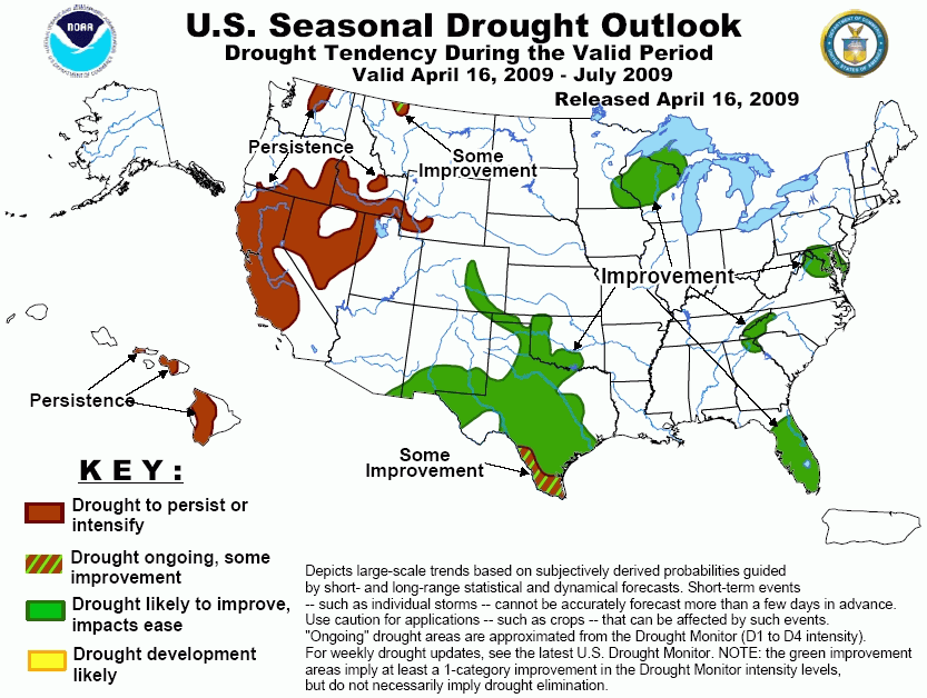
Moderate to heavy rains eased drought impacts across the central Gulf Coast, the Southeast outside the Florida
Peninsula, the middle Atlantic region, and parts of the southern Plains over the last few weeks, helping to
bring numerous wildfires under control across western Oklahoma and northern Texas. Other drought-affected parts
of the country saw conditions persist during this period, with some expansion and deterioration noted in a few
areas. The Drought Outlook through the end of July 2009 is generally pessimistic in western sections of the
country, with the likelihood of improvement increasing farther east. Mid-April precipitation should reduce
impacts of the moderate drought in the mid-Atlantic region and the interior Southeast, and typical seasonal
increases in precipitation should bring improvement to the Florida Peninsula and the Great Lakes region later in
the forecast period. Across the southern Plains, where the most serious drought conditions are currently
entrenched, heavy rainfall in some areas during the last half of April and typically wetter May-July conditions
should bring improvement to most areas, though recovery in far southern and southwestern Texas may be less
robust. Farther west, odds favor drier than normal May-July conditions and therefore persisting drought across
the interior West, and the low precipitation amounts typical of this time of year along the Pacific Coast and in
Hawaii should keep drought intact across those areas as well.
|
|
Tools used in the Drought Outlook included the
official CPC precipitation outlook for May 2009 and the long lead forecast
for May - July 2009, the four-month Palmer drought termination and amelioration probabilities, various medium-
and short-range forecasts and models such as the 6-10 day and 8-14 day forecasts, the soil
moisture tools based on the GFS model and the Constructed Analogue on Soil (CAS) moisture, the
Climate Forecast System (CFS) seasonal precipitation forecasts, and climatology.
The areas of moderate drought across the
mid-Atlantic and the interior Southeast should see at least moderate precipitation during the last half of
April 2009. The ensuing 3 months typically bring about 25 percent of annual precipitation totals to these
areas. Forecasts for this period are non-committal, thus based only on climatology, near- or above-normal
rainfall is more likely than substantially below-normal precipitation, so the odds favor improvement for
these areas, though not overwhelmingly so.
Forecast confidence for the mid-Atlantic and interior Southeast is moderate given the uncertainty of
May-July conditions.
Across peninsular Florida, generally dry weather
seems likely through the end of April. Thereafter, either above- or below-normal rainfall seem equally
likely during May-July, but normals for this period are much higher than during the winter season, ranging
from 30 percent to 40 percent of annual totals on average. Since the current drought originated during the
winter dry season now winding down, at least surface moisture increases are a good bet during the forecast
period, and historically, May-July rainfall totals sufficient to significantly reduce or eliminate the
existing accumulated 2008-2009 dry-season rainfall deficits have been fairly common.
Forecast confidence across Florida is high.
Substantial if not exceptionally heavy
precipitation is likely through the end of April across the Great Lakes region, and similar to the situation
across the Florida Peninsula, the forecast for May-July is non-committal but seasonal increases in
precipitation should be sufficient to bring relief to the region. However, unlike in Florida, moisture
shortages date back considerably longer than just the last few months, so the likelihood for recovery is a
bit lower.
Forecast confidence across the Great Lakes region is moderate.
In the southern Plains, where the nation's most
serious drought conditions currently reside, moderate to heavy rain is expected for a large part of the
drought areas in the eastern two-thirds of Texas and, to a lesser extent, western Oklahoma and eastern
Colorado during April 16-20, 2009, and the odds favor above-normal rainfall toward the end of April in
southern Texas. Other parts of the drought areas farther to the west and near the Rio Grande look to be
relatively dry for the rest of April. However, May-July precipitation is normally much heavier than during
the cooler time of the year for areas to the north and west of central Texas, with monsoonal rainfall
typically moving into the southern High Plains during July. For all these reasons, most drought areas in the
southern Plains should experience improvement by the end of July 2009, although only limited improvement is
expected in southern and southwestern Texas, where relatively dry conditions are expected for the last half
of April and where the May-July increase in normal precipitation is not so marked as is the case farther
north.
Forecast confidence across the southern Plains is moderate to high.
Relatively dry weather is expected in northern
Montana through the rest of April 2009, but the evolution of drought conditions thereafter is unclear at
best. The May-July period is typically one of the wetter times of the year, but the odds appear to favor
below-normal precipitation for this period in 2009, albeit weakly, in at least part of the drought region.
Given the relatively wet time of year, at least some improvement in surface moisture conditions seems likely,
but the forecast favoring below-normal totals for the period as a whole raises the possibility of
deteriorating hydrologic conditions by the end of July.
Forecast confidence across northern Montana is low.
There should be very little precipitation in the
drought areas from the central Rockies westward to the Pacific Coast during the last half of April 2009, save
for some light to moderate amounts from the central Great Basin and adjacent Intermountain West eastward
through southwestern Wyoming before April 20. Thereafter, May-July typically features a sharp drop in
precipitation relative to the wet winter for the West Coast states, and this year should be no exception.
May-July normals across the drought areas of the interior West from Nevada and southeastern Oregon eastward
through southwestern Wyoming decline much more modestly if at all, but the odds favor below-normal
precipitation for these areas during May-July 2009. As a result, drought should persist everywhere it exists
from the central Rockies westward.
Forecast confidence across the West Coast states and the central interior West is high.
Normal rainfall amounts drop off during May-July
relative to wetter winter conditions in Hawaii, though not to the degree observed in places along the West
Coast like California. Drought therefore is expected to persist where it exists, but because the 3-month
outlook is non-committal and climatology indicates that amounts have the potential to be large enough to
significantly impact existing deficits, some degree of uncertainty exists.
Forecast confidence across Hawaii is moderate.
|


