|
Latest Seasonal Assessment -
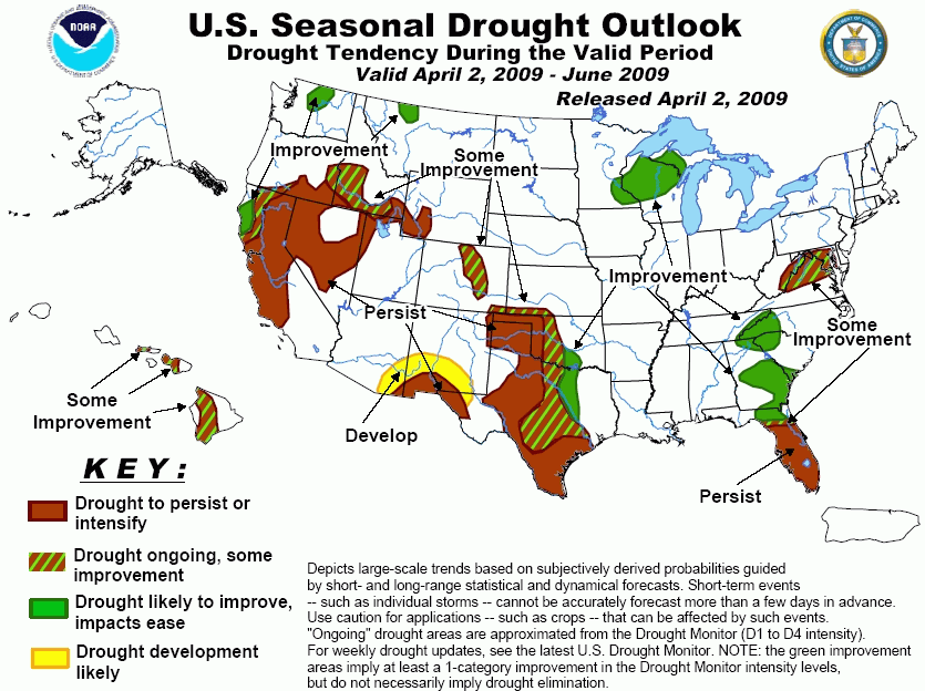
Above normal rainfall in March helped ease drought conditions over eastern Texas,
along the Gulf coast, and parts of the southeast. Nevertheless, severe drought continued in
parts of Texas and Oklahoma. An improving trend will continue over parts of the region, with the best
odds for reduced drought in central and eastern portions of both states.
The abnormally dry area along the Gulf Coast and over southern Alabama and Georgia has seen
significant relief. In fact some of these areas are currently undergoing flooding.
A wetter than normal pattern is expected to continue along the eastern Gulf Coast and over parts
of the Southeast in the short and medium range. Heavy snow has offered some relief for the drought area
over Colorado. Additional heavy snow is possible over the region during the beginning of the current
forecast period. Further south over southern New Mexico little rainfall fell during March.
Medium and longer range forecasts indicate near to below normal rainfall
over the region so there is a good chance drought may expand
northward in New Mexico and westward into southern Arizona.
Drought has been intensifying over most of Florida, especially the central and southern
part of the state. Drought is expected to persist over the central and southern
parts of the state during May. On the other hand, heavy rainfall has ended drought over the Florida
Panhandle and parts of northern Florida. The start of the
thunderstorm season later in May should begin to ease drought conditions,
elsewhere in Florida. Farther north, drought is expected to continue to improve over the interior Southeast.
In the mid-Atlantic region, a dry winter and early spring has lead to unseasonably low streamflow and well
levels and the development of moderate drought over part of the area. Rainfall is forecast
to increase over the region during the short and medium ranges which would result
in some improvement. Drought areas in the Upper Midwest and parts of the Northwest
should see improvement, while the bulk of the improvement is likely over for California
and the Great Basin as the wet season winds down. Rain and snow forecast for early in April will keep
California on pace for a near-normal water year, but will not be enough to make up for the multi-year deficits.
|
|
Tools used in the Drought Outlook included
the official updated CPC precipitation outlook for April and the long lead forecast
for April – June 2009, the four-month Palmer drought termination and amelioration probabilities, various
medium- and short-range forecasts and models such as the 6-10 day and 8-14 day forecasts, the
soil moisture tools based on the GFS model, the Climate Forecast System (CFS) seasonal precipitation
forecasts, and climatology.
In California and the Great Basin, the wet
season is winding down, making additional drought relief more difficult. Unlike last year, the storms
have continued into March, and at least one more beneficial storm is forecast only a few days into the
forecast period. The additional rain and snow will keep California and adjacent parts of Nevada on pace
for a near-normal water year, but the forecast precipitation from this storm and potentially from additional
events later in April will likely not be sufficient to make up for the deficits accumulated during the
past 3 years. Forecast spring-summer streamflows remain below normal, and the large reservoirs in the north
will not fill up despite the marked improvement seen since the stormy period began in February. As a result,
the Drought Outlook indicates persisting drought for most of California and the Great Basin, except for
a small area in northern California where spring storms should have the most impact. The updated CPC
monthly forecast for April indicates equal chances for above or below normal precipitation over most of
the region except for southeastern California and southern Nevada where below median precipitation amounts
are forecast. The CPC long-lead precipitation forecast for April-June leans toward below normal
precipitation for the northern Great Basin, and this contributed to a somewhat more negative outlook for
that region. The limited improvement shown for southern Idaho is mainly based on the wet forecast for the
first 2 weeks of the forecast period.
Forecast confidence for California and the Great Basin is high.
Increased moisture forecast by the short -range
models supports the improvement shown for the small drought areas in Washington and Montana. Medium-range
models indicate mostly near normal precipitation with a slight tendency for below median precipitation for
part of the area. The CPC updated monthly forecast for April forecasts equal chances for any particular
precipitation category over the region. The CPC long-lead precipitation forecast for April-June leans toward
below normal precipitation for these areas which is offset to some extent by the expectation that temperatures
will be below normal.
Forecast confidence for Washington and Montana is moderate.
The small area of drought over Wisconsin is expected
to see improvement due to light to moderate precipitation forecast over the next 5 days, forecasts of mostly
near normal precipitation during the medium-range, and forecasts of equal chances for a given category in
CPC's updated monthly forecast for April, and the long lead forecast for April-May-June.
The drought expansion depicted in the Southwest
in Arizona and New Mexico is based on initial dry areas, forecasts of little to no precipitation in the short
range, near normal precipitation in the medium range, above normal temperatures and below normal precipitation
during April, and above normal temperatures with near normal precipitation during April-May-June. La Niña
composites for New Mexico tend toward below-normal rainfall during April-June.
Forecast confidence for Arizona and New Mexico is moderate.
The area of some improvement forecast for Colorado,
southern Kansas, central Oklahoma, and central Texas is based on short and medium range forecasts of near
to above normal precipitation for those regions offset by the CPC forecasts of equal chances for any given
precipitation category during April, and equal chances or below median precipitation during April-May-June.
Improving conditions are shown for eastern parts of the drought area extending into central Texas.
This is based on the monthly CFS volumetric soil moisture change from initial anomalies forecasts for April,
May and June, forecasts of equal chances for any given precipitation category in CPC's updated monthly
forecast for April and the long lead forecast for April-May-June, and climatology. May and June tend to be
wet months for Texas, especially in the east. The area shown in green was in marginal drought to begin with,
so most susceptible to eradication. There is considerable uncertainty about the location for improvement in
the drought region given the range of possible weather developments into June. La Niña composites tend to
show below-normal rainfall for southern Texas during April-June, consistent with the persisting drought area
shown on the Outlook map. The persisting drought area forecast for western Oklahoma and west/central Texas is
based on La Niña soil moisture composites, the CPC updated forecast for April which depicts a likelihood of
near to below median precipitation, and medium range forecasts which suggest near normal precipitation
amounts for southern and western Texas. The medium-range forecast indicates above median precipitation for
parts of Oklahoma and the Panhandle of Texas, which reduces confidence in the forecast of drought persistence
for those regions.
Forecast confidence for the central and southern Plains is low.
For the central Gulf Coast, recent very heavy
precipitation has alleviated the drought. Short and medium range forecasts suggest a continuation of the
wetter than normal pattern for the region so that drought re-development over the region during the forecast
period seems unlikely.
In Florida, drought has been intensifying over the
central and southern part of the state. The La Niña appears to be having an influence in steering storms
to the north. Confidence for persisting or worsening drought is quite high for the central and southern parts
of the Peninsula. This idea is supported by the forecast of only light precipitation in the next 5 days, the
forecast of near normal precipitation during the medium range, and below median precipitation for these areas
in the CPC updated monthly forecast for April, and the CPC long lead seasonal forecast for April-May-June.
With the onset of the warm season thunderstorm season later in May some improvement is likely to begin by
then, accelerating into June. The Outlook map could have indicated this temporal variability by depicting an
area of some improvement, but the drought impacts should be serious for a significant part of the forecast
period, and this warranted the more pessimistic depiction on the map. Wildfires and water shortages are
a very real risk. Recent heavy rains have eased dryness over the Florida Panhandle and reduced drought over
northern parts of the state. Additional heavy rain is expected over the Florida Panhandle and northern
Florida.
Forecast confidence for Florida is moderate.
To the north, heavy March rains eased dryness in
Alabama and Georgia and much of the interior Southeast. Streamflows have recovered to close
to normal over much of the area, and are actually above normal over southern Alabama and southern Georgia,
although wells in parts of Georgia and in northwestern South Carolina remained low for this time of the year
due to the long-term rainfall deficits. Lake Lanier levels in northern Georgia were still around 10 feet below
normal. Rainfall is expected to be above normal over the next 5 days, especially over the southern part of
the region. Medium range forecasts and the CPC updated monthly forecast for April indicate the likelihood
that the wetter than normal pattern will continue. La Niña composites also are consistent with rainfall
increasing and dryness decreasing northward from Florida. As a result, the Outlook depicts improvement over
northern Florida, southeastern Georgia, and for the areas north of there. Nevertheless, some water shortages
may continue into summer, as it is too late in the recharge season to expect lakes and wells to fully recover
before water demand increases with the warm weather.
Forecast confidence for the interior Southeast is moderate.
The mid-Atlantic region got off to a slow start
this year, with precipitation since January 1 only about one-half of normal in Washington DC, Baltimore, and
Philadelphia. Some rainfall is expected over the next 5 days, and medium range forecasts indicate above
median precipitation for much of the area. Streamflows remain very low over the region especially over the
Maryland, Delaware and Pennsylvania. The CPC updated monthly forecast for April and the CPC seasonal forecast
for April-May-June indicate equal chances for both temperature and precipitation categories. La Niña
composites tend to show drier than normal over the area for spring. For these reasons a forecast of some
improvement was specified for the region.
Forecast confidence in the mid-Atlantic is low.
Long-range rainfall forecasts point to some
improvement for drought conditions for Hawaii, so the Outlook shows hatched some improvement in the scattered
drought areas remaining on several of the islands.
Forecast confidence in Hawaii is moderate.
|


