|
Latest Monthly Assessment -
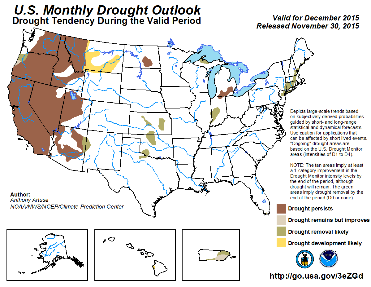
The Pacific Northwest has had a very active start to its wet season, and this wet pattern is forecast to continue well into
December. Portions of the Oregon coast may experience drought improvement or removal, while drought persistence is favored across
the remainder of the Northwest. Some of the storm systems expected to sweep across the Northwest are forecast to bring
precipitation to northern California, but not enough is anticipated to warrant drought improvement in December. Drought is likely to
persist across the Intermountain region, develop across central and eastern Montana, and persist in North Dakota. The current El
Niño favors a southern storm track and associated jetstream, which is the main impetus behind the predicted removal of existing
drought conditions across New Mexico, the central and southern Plains, the Lower Ohio Valley, and the Northeast. The most uncertain
part of this outlook is over the Great Lakes area, where the dry signal typically associated with El Niño has not yet become fully
established. Short-term gains in precipitation may be enough to justify drought removal in Upper Michigan, but confidence is low.
Recent heavy rains across much of Hawaii have helped to delay the onset of dryness typically associated with El Niño. Small areas of
drought are possible, however, across southern Maui, and the Kona region of the Big Island. Puerto Rico is anticipated to see a
1-category improvement overall in drought conditions, due to typical impacts from an El Niño.
|
|
Tools used in the U.S. Monthly Drought Outlook (MDO) included the official Climate Prediction Center (CPC) updated temperature and
precipitation outlooks for December 2015, various short- and medium-range forecasts and models such as the 7-day precipitation
totals from the Weather Prediction Center (WPC), the 6-10 day and 8-14 day CPC Extended-Range Forecasts (ERFs), Weeks 3 and 4
experimental outlooks, the NAEFS precipitation outlooks, dynamical models including the CFSv2 and GFS, climatology, El Niño
composites, and initial conditions.
During the past 30-days, the Advanced Hydrologic Prediction Service (AHPS) analysis depicts surplus precipitation across western
Washington state, northwestern Oregon, and the northern Rockies. The greatest Departures from Normal Precipitation (DNPs) range
from 5-8 inches or more above normal (liquid equivalent) across the higher terrain of western Washington and northwestern Oregon.
AHPS also indicates deficit precipitation (generally 1-3 inches below normal, with localized areas of 3-5 inches or greater below
normal) during this same period across southwestern Oregon. Precipitation forecasts out through 2 weeks favor above-median
precipitation across much of the Northwest, with the greatest probabilities closer to the Pacific coast. Five to eight inches of
precipitation (liquid equivalent) is anticipated for much of the Oregon coast in just the first week of December. For Weeks 3 and
4, and for December as a whole, Equal Chances (EC) is forecast closer to the coast, while the odds for below-median precipitation
are elevated across the interior, which is more consistent with an El Niño. Based on the above considerations, drought
improvement/removal is favored near the Oregon Coast, while drought persistence is deemed more likely across the remainder of the
region.
Forecast confidence for the Northwest is moderate.
Much of the northern third of California reported a shortfall in precipitation during the past 30-days. The western half of this
region, in particular, had DNPs ranging from 4-8 inches below normal. AHPS indicates the Los Angeles basin in southern California,
and much of northern Utah, have deficits ranging from 1-3 inches during this observed 30-day period. Portions of both Arizona and
New Mexico received precipitation surpluses of 0.5-2.0 inches. The precipitation forecast from WPC covering the next 4-7 days
predicts about 1.0-1.5 inches (liquid equivalent) for northern California (perhaps more in the Sierras) and 0.10-0.25 inch for
northern Nevada and northern Utah. CPC's 6-10 day precipitation outlook favors below-median precipitation across California and the
Southwest, with the return of Pacific moisture for northern California and northern Nevada during Week 2. The experimental Weeks 3
and 4 precipitation outlooks from CPC favor at least a 50-50 chance of wetter-than-median conditions for Arizona and New Mexico,
and at least a 50-50 chance of drier-than-median conditions across northern Utah. With CPC's updated 30-day outlook also favoring
wetness across New Mexico, it was decided to go with drought removal there. Based on the spatial coverage and intensity of the
drought currently in California (and to a lesser degree in the Southwest), drought persistence is considered the best bet. This is
especially true for California, where historically, El Niño events tend to bring the greatest precipitation amounts after the
month of December.
Forecast confidence for California is high, and for the Southwest, moderate.
The northern Great Plains has largely missed out on the abundant precipitation that fell across the central and southern Plains
during the past month. In drier climates such as the High Plains, it is generally more helpful to inspect the Percent of Normal
Precipitation (PNP) patterns, rather than the DNP patterns. In this situation, the PNP pattern clearly depicts where the
precipitation has been lacking, namely in a broad band stretching from northeastern Wyoming to north-central North Dakota. PNPs
span from the 5th to the 75th percentiles through this region, with the driest conditions depicted over southwestern North Dakota,
extreme southeastern Montana, northeastern Wyoming, and northwestern South Dakota. In contrast, PNPs ranged from 150-400 percent or
greater across Nebraska, western Kansas, northeastern and far eastern Colorado, and large portions of both Texas and Oklahoma.
Precipitation forecasts through December favor continued dryness for the northern Plains, with drought expected to persist in North
Dakota, and develop across Montana. Above-median precipitation is predicted for most time scales out through one month across the
central and southern Plains, warranting the removal of pre-existing drought in those areas.
Forecast confidence for the Great Plains is moderate.
The western Great Lakes region received upper-tercile precipitation amounts during the last 30-days (DNPs 0.5-3.0 inches
above-normal), though the current drought area over Upper Michigan has seen amounts closer to normal (DNPs less than 1.0-inch
above-normal). Precipitation across southern Lower Michigan has been close to normal, implying at least a temporary offsetting of
additional deterioration in local drought conditions. Western Indiana has received near- to slightly above-normal precipitation in
the past 30-days. Precipitation for the Great Lakes and Lower Ohio Valley for the next few weeks is expected to be hit or miss, and
there is no clear-cut, large-scale circulation pattern stable enough on which to base the outlook. Even the updated 30-day outlook
for December predicts EC across this area, underscoring the uncertainty. It looks as though Upper Michigan may get enough
precipitation during the month to warrant drought removal, but confidence is low.
Forecast confidence for the Great Lakes region and Lower Ohio Valley is low.
Near the Northeast coast, 30-day DNPs ranged from 1-3 inches below normal. WPC predicts light to moderate (0.3-0.7 inch) rain
during the first few days in December across this area of lingering drought, and CPC's extended-range forecasts (days 6-14) favor
below-median precipitation. The experimental Weeks 3 and 4 outlooks depict an East Coast storm track, with at least a 50-50 chance
of upper-tercile precipitation as far north as Long Island, NY. It is well known that droughts rarely last that long in this region,
because of its proximity to the mean storm track and mean position of the polar jetstream. Given these conflicting considerations,
drought removal still remains the best bet for this area.
Forecast confidence for the Northeast is low to moderate.
In extreme southern Florida, the past 30-days has seen a somewhat drier pattern than normal. With nearly all time scales out to a
month in advance favoring wetness in this region, confidence is high that the residual drought will be removed.
Forecast confidence for Florida is high.
A recent soaking rainfall over portions of Hawaii resulted in the removal of abnormal dryness (D0) from Kauai and Oahu in the latest
United States Drought Monitor. D0 conditions persist, however, in southern Maui and across the Kona region of the Big island.
Although suppressed rainfall is characteristic of a late autumn/early winter El Niño, the recent rainfall may be enough to
delay the onset of drought development for most areas until after December, with the exceptions of southern Maui and the Kona
region of the Big Island.
Forecast confidence for Hawaii is moderate.
Climate anomalies associated with El Niño favor above-normal rainfall across Puerto Rico during the dry season. A
one-category improvement is predicted across the island, with D2 (severe drought) expected to improve to D1 (moderate drought), and
D1 areas expected to go to D0 (abnormal dryness, hence drought removal).
Forecast confidence for Puerto Rico is moderate to high.
There are currently no drought areas in Alaska. Regions of abnormal dryness (D0) are expected to lock into place with freezing
ground/soil.
Forecast confidence for Alaska is high.
|


