|
Latest Monthly Assessment -
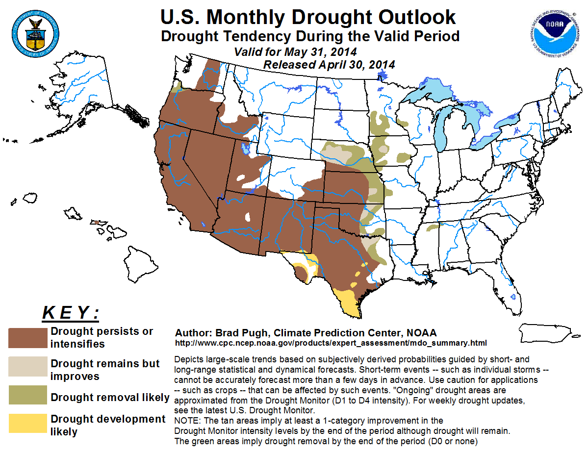
The monthly drought outlook valid for May is based primarily on initial conditions, climatology, and precipitation forecasts
during the next month. Persistence is expected for nearly all of the ongoing drought areas of the West since May is a
relatively dry month when widespread improvement is not anticipated. Drought intensified during April across the central and
southern Great Plains. The beginning of May is expected to be mostly dry with increasing heat across Kansas, Oklahoma, and
Texas. Therefore, drought is likely to intensify early in the month. However, the pattern is expected to become more
favorable for much-needed rainfall by the second week of May. Persistence is most likely for the protracted drought areas of
the high Plains, while prospects for drought improvement or removal increase for eastern Kansas, eastern Oklahoma, and
northeast Texas. Development forecast for south Texas is based on recent trends and the expected dry, hot weather at the
beginning of May. Enhanced odds for above-median precipitation are forecast across Nebraska and the Midwest during May which
favors improvement or removal for most of these areas during this relatively wet time of year.
An exceptionally wet storm system brought widespread heavy rainfall to much of the eastern U.S. during the final week of
April. Therefore, the eastern U.S. is expected to remain drought-free through the end of May.
|
|
Tools used in the U.S. Monthly Drought Outlook (MDO) included the official Climate Prediction Center (CPC)
temperature and precipitation outlooks for May 2014, various short- and medium-range forecasts and models such as the 5-day and 7-day precipitation
totals from the Weather Prediction Center, 6-10 day and 8-14 day CPC forecasts, the NAEFS precipitation outlooks,
the soil moisture tools based on the Constructed Analog on Soil (CAS) moisture,
dynamical models (CFSv2, NMME, and IMME), the 384-hour total precipitation forecasts from several runs of the GFS,
climatology, and initial conditions.
Drought intensified across northern California during April. Above-normal temperatures during the past month resulted
in parts of the Sierras becoming snow-free early, while snow-water equivalent rankings were generally at the 20th
percentile or lower in areas with a snowpack at the end of the month. The intensity levels of drought remained steady
across southern California. According to the U.S. Drought Monitor (USDM) on April 22, extreme to exceptional drought
covers 17.9 percent of the state. Persistence of drought is likely for California due to a dry climatology during May.
Forecast confidence for California is high.
Near to above-normal precipitation continued during April for Washington, northern Oregon, and the northern Great Basin,
while southwest Oregon experienced below-normal precipitation. Snow-water equivalent values generally range from
above-normal across the northern Cascades to below-normal across the southern Cascades and much of the Great Basin. A
small area of drought removal is forecast for northwest Oregon where 1 to 3 inches of precipitation is expected during
the first week of May. Although the CPC precipitation outlook for May indicates enhanced odds for above-median
precipitation for the remainder of the Pacific Northwest and Idaho, precipitation amounts are not expected to be enough
to warrant widespread drought improvement. Forecast confidence for persistence is highest across the southern Great Basin
where climatology becomes much drier during May.
Forecast confidence for the Pacific Northwest and Great Basin is moderate.
Above-normal temperatures during April resulted in drought expansion and intensification across the Southwest. As of the
April 22 USDM, nearly a quarter of New Mexico is designated in the extreme or exceptional drought category. Excluding
eastern New Mexico and southeast Colorado, May is a very dry time of year for the Southwest. Therefore, drought is likely
to persist for this region. Persistence if forecast for southeast Colorado and eastern New Mexico, where extreme to
exceptional drought is entrenched and heavy precipitation would be necessary for improvement in a one month time span.
Forecast confidence for the Southwest is high.
Rainfall typically begins to increase during April across the central and southern Great Plains. However, rainfall
deficits during the past 30 days ranged from 2 to 3 inches across south-central Kansas and north-central Oklahoma. This
inadequate precipitation combined with above-normal temperatures and frequent high winds intensified drought conditions
across these areas. Drought remained nearly steady across Nebraska with the most intense drought affecting southwest
parts of that state. Although May is the wettest month of the year for Oklahoma, a dry start to the month with increasing
heat favors persistence for the western half of Oklahoma. Improvement or removal for east-central Oklahoma is based on
climatology and the increased chances of above-median rainfall forecast by the CPC 6-10/8-14 day outlooks. Persistence is
most likely for the protracted drought areas of western Kansas. Meanwhile, a favorably wet pattern beginning by the
second week of May is expected to result in drought improvement or removal across eastern Kansas and much of Nebraska.
The CPC monthly outlook indicates enhanced odds for above-median precipitation across these areas as the convective
season peaks.
Forecast confidence for the central/southern Great Plains is moderate.
Drought coverage and intensity increased across Texas during April with the largest precipitation deficits ranging from
1 to 3 inches. Mostly dry weather coupled with increasing heat is likely to intensify ongoing drought and result in
development across south Texas and the Big Bend region. The most likely area for improvement or removal of drought is
northeast Texas, close to the Red River. Model guidance on April 30 indicates an amplified trough developing across the
western U.S. during early May, which would favor above-median rainfall during days 6-10 and 8-14 for much of Texas.
However, the dry and hot start to the month along with intensifying drought during the latter half of April temper the
expectation for improvement across Texas.
Forecast confidence for Texas is moderate.
Occasional precipitation continued to reduce drought coverage and intensity across the Midwest during April. Additional
improvement or removal for this region is based on climatology and a tilt in the odds towards above-median precipitation
forecast by the CPC monthly precipitation outlook. The second week of May is expected to be quite wet as a trough
develops across the western U.S. It should be noted that subsoil moisture remains short across parts of the Midwest which
makes this region vulnerable to rapidly developing summer drought if a period of extreme dryness and heat occur.
Forecast confidence for the Midwest is high.
The only remaining small moderate drought area (as depicted on the April 22 U.S. Drought Monitor) exists on Molokai.
This drought area is associated with low water levels on the Kualapuu reservoir. Since the Hawaiian Islands are entering
their dry season, persistence is forecast for the remaining drought area in Hawaii.
Forecast confidence for Hawaii is moderate.
|


