|
Latest Monthly Assessment -
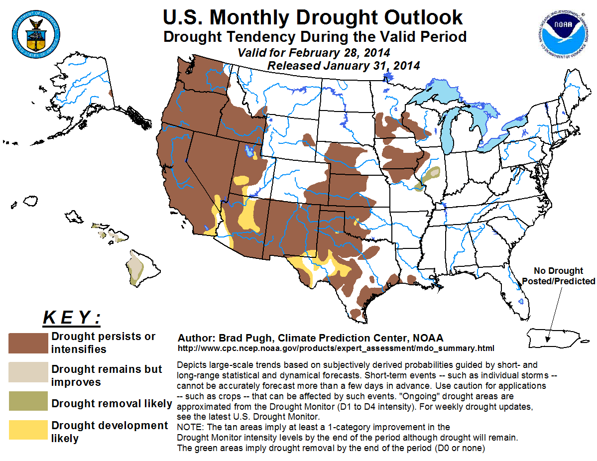
Moderate drought expanded north along the West Coast during January, while drought intensified across California. According to
the U.S. Drought Monitor (USDM) valid January 28, 2014, 8.77% of California is designated as exceptional drought (D4) for the
first time in the nearly 15-year history of the USDM. Drought also expanded to include nearly all of New Mexico and much of the
western Gulf Coast. Drought coverage and intensity was steady for the Midwest which is typical for winter. The Northeast became
drought-free during January with abnormal dryness continuing for parts of the Florida peninsula.
The February drought outlook is based on initial conditions, the WPC 7-day precipitation forecast, the CPC 6-10/8-14 day
precipitation outlooks, and the CPC monthly precipitation outlook. Large precipitation deficits and very low snow-water
equivalent values favor drought persistence across the West through the end of February. Although a wetter pattern is expected
across the Pacific Northwest during the first two weeks of February, the upcoming precipitation is not expected to offset the
unseasonably dry winter through January. Forecast confidence is relatively high for intensification of drought across central
and southern California due to the CPC monthly precipitation outlook favoring below-median precipitation for this region.
Development of drought across the remainder of the Southwest is based on a lack of adequate snow this winter and enhanced odds
for below-median precipitation forecast by the CPC monthly outlook.
Precipitation early in the month is expected to preclude additional drought development across the central/southern Great
Plains and western Gulf Coast. However, a lack of a wet signal beyond the first week of February results in persistence for
these areas through the end of February.
A relatively dry climatology favors persistence for most of the ongoing drought areas of Iowa, Minnesota, northern Missouri,
and Wisconsin. Prospects for improvement or removal increase across east-central Missouri and Illinois due to heavier
precipitation amounts anticipated early in February.
The eastern third of the U.S. is forecast to remain drought-free through the end of February. Parts of the Florida peninsula
are most vulnerable to drought development, but recent rainfall is expected to slow the onset of drought.
Removal or improvement of drought is expected across Hawaii due to climatology and a wet start to February.
|
|
Tools used in the monthly U.S. Drought Outlook (MDO) included the official CPC temperature and precipitation outlook
for February 2014, various short- and medium-range forecasts and models such as the 6-10 day and 8-14 day forecasts, the
NAEFS and ESRL precipitation outlooks, the soil moisture tools based on the Constructed Analog on Soil (CAS)
moisture, dynamical models (CFSv2, NMME, and IMME), the 384-hour total precipitation forecasts from several runs of the
GFS, the 7-day quantitative precipitation forecast from the NCEP Weather Prediction Center (WPC), climatology, and
initial conditions. ENSO conditions continue to be and are forecast to remain neutral.
A persistent, upper-level ridge across the east Pacific began to weaken during late January. However, the persistence of
this ridge during much of the wet season resulted in large precipitation deficits dating back to October 2013. For
example, precipitation deficits from October 1, 2013 through January 28, 2014 are around 10 inches for Portland and
Seattle. According to the Western Regional Climate Center, river basin snow water content values as of January 30 are
running at the lowest 5th percentile across the southern Cascades and Sierra Nevada mountains. During the first half of
February, a strong ridge anchored over the Aleutians is expected to result in onshore flow, favoring above-median
precipitation amounts across the Pacific Northwest and northern California. However, the drought level status designated
by the U.S. Drought Monitor (USDM) is most likely to remain unchanged through the end of February 2014 across the Pacific
and northern California due to the very dry initial conditions. Intensification of drought is expected across the
southern half of California due to precipitation tools favoring below-median precipitation during the next month.
Forecast confidence ranges from high across southern California to moderate across northern California and the Pacific
Northwest.
Initial conditions are also quite dry for the interior West where river basin snow water content values are running
below-average across most of Idaho, Nevada, Utah, and the Southwest. Since mid-January, the USDM depicted an increase in
moderate to severe drought across New Mexico. The CPC seasonal precipitation outlook calls for enhanced odds for
below-median precipitation across the Southwest with equal chances across the northern Great Basin. A lack of a wet
signal among the tools and initially dry conditions support persistence of drought across the interior West and
Southwest. Parts of Arizona and southwest Utah (designated with DO or abnormal dryness in the January 28 USDM) are primed
for development during the next month with snow water equivalent values ranking in the lowest 20th percentile.
Forecast confidence for persistence (development) is moderate (low) across the interior West and Southwest.
The central and southern Great Plains received little precipitation during the past 30 days. According to the Oklahoma
Mesonet, most locations across western and central Oklahoma recorded less than 0.10 inches of precipitation during
January. The lack of precipitation and frequent gusty winds associated with frontal passages resulted in blowing dust and
a number of wildfires. The WPC 7-day precipitation forecast on January 31 indicates moderate amounts of precipitation
(around 0.5 inches, liquid equivalent) during the first week of February, while the CPC 8-14 day outlook calls for a
tilt in the odds toward below-median precipitation amounts during the second week of February. The expected precipitation
early in February is expected to prevent an expansion of drought coverage across the central and southern Great Plains
but improvement of the ongoing drought is not likely.
Forecast confidence for the central and southern Great Plains is moderate.
Since the seasonal outlook was released on January, moderate drought increased in coverage across southeast Texas. 60-day
precipitation deficits range from 4 to 8 inches across east Texas and Louisiana. A wetter pattern is expected to develop
for this region early in February. The WPC 7-day precipitation forecast on January 31 calls for a widespread 1 to 2
inches of rainfall, while the CPC 8-14 day precipitation outlook favors near median precipitation amounts. Persistence is
forecast for the ongoing drought areas of southeast Texas and Louisiana but small areas of improvement may occur with
locally heavy rainfall during early February.
Forecast confidence for southeast Texas and southern Louisiana is low.
February is a relatively dry month for the Midwest with less than 5 percent of the annual precipitation occurring
climatologically. During the first week of February, moderate to heavy snow (0.5 to 1.5 inches, liquid equivalent) is
forecast for northern Missouri and Illinois. Near to above-median precipitation amounts are favored during the second
week of February according to the CPC 8-14 day precipitation outlook. The expected wetness early in February favors
removal or improvement of drought conditions parts of Missouri and Illinois where the heaviest precipitation amounts are
forecast. If soils remain frozen through the end of February, then changes in drought status may be delayed until March.
Drought is likely to persist across Iowa, Minnesota, and Wisconsin where lighter precipitation amounts are expected early
in February and with a drier climatology across these areas.
Forecast confidence for the Midwest is low.
A small area of moderate drought continues in east-central Alaska. The CPC monthly outlook calls for equal chances of
below, near, or above median precipitation during February. No changes are expected by the end of February since this is
a long-term drought area.
Forecast confidence for Alaska is low.
The CFS and GFS models remain consistent that above-normal precipitation will affect the Hawaiian Islands during early
February. The CFS model on January 31 indicates large positive anomalies of precipitation for Hawaii during Week-2. These
consistently wet forecasts and climatology support improvement or removal of drought across Hawaii.
Forecast confidence for Hawaii is moderate.
|


