|
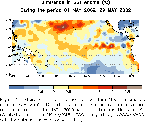
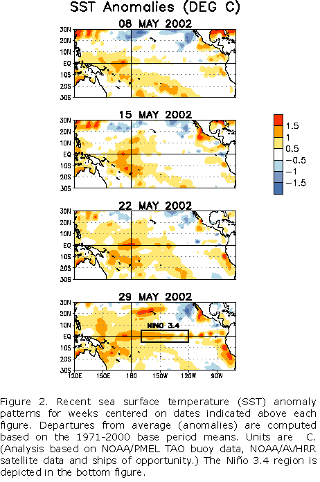
Further evolution toward a Pacific basin-wide warm
episode (El Niño) was observed during May 2002, as sea surface temperature (SST)
anomalies increased throughout the equatorial Pacific between 170°E and 95°W (Fig. 1 and Fig. 2). By the end of May
warmer-than-normal SSTs were observed over a large portion of the equatorial Pacific (Fig. 2, bottom panel), with departures from average greater than
+1°C in the region from 165°E to 135°W and also locally between 130°W and the South
American coast. This warming represents a significant transition from the localized warmth
(central equatorial Pacific and South American coast) earlier this year, observed during
recent months, toward a more extensive basin-wide warming typical of El Niño/Southern
Oscillation (ENSO) events.
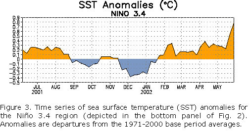
This warming resulted from a significant weakening of the equatorial easterly winds
throughout the Pacific related to the Madden-Julian Oscillation (MJO). The MJO is an
important source of variability that can contribute to the evolution toward El Niño
through related fluctuations in low-level winds and precipitation over the western and
central equatorial Pacific. An eastward-propagating oceanic Kelvin wave, initiated by
strong MJO activity in late 2001, resulted in the rapid warming that was observed along
the coasts of Ecuador and northern Peru in early February. Subsequently, MJO activity was
relatively weak during early 2002, with no additional significant Kelvin wave activity
during that period. However, in late April 2002 the MJO intensified and during the last
half of May the low-level equatorial easterly winds substantially weakened throughout the
Pacific, accompanied by an increase in equatorial SST anomalies (Figs. 1, 2, and 3).
NOAA TAO buoy data indicate that the oceanic thermocline has deepened east of the date
line (180°W) since mid-May, consistent with the basin-wide weakening of the low-level
equatorial easterly winds. This deepening may be an indication of renewed Kelvin wave
activity.
Given the recent strength of the MJO and its period of about 40 days, it is likely that
significant month-to-month fluctuations will continue to occur in many atmospheric indices
used to monitor the ENSO cycle. In spite of this variability, the overall trends in SSTs
and some atmospheric indices (Southern Oscillation Index, 850-hPa zonal wind) in recent
months indicate that further development of El Niño will continue. Consistent with this
assessment, most statistical and coupled model forecasts indicate that weak-to-moderate El
Niño conditions will continue through the end of 2002.
This discussion is a team effort of NOAA and its
funded institutions. Updates of SST, 850-hPa wind, OLR and the equatorial subsurface
temperature structure are available on the Climate Prediction Center web page at
http://www.cpc.ncep.noaa.gov (Weekly Update). Forecasts for the evolution of
El Niño/La Niña are updated monthly in CPC's Climate Diagnostics Bulletin Forecast Forum. To receive
an e-mail notification when updated ENSO Diagnostic Discussions are released please send
your e-mail address to:
|


