|
Synopsis:
El Niño conditions are likely
to continue through March-May 2007.
Equatorial Pacific SST anomalies greater than +1ºC
were observed in most of the equatorial
Pacific between 170ºE and the South American coast
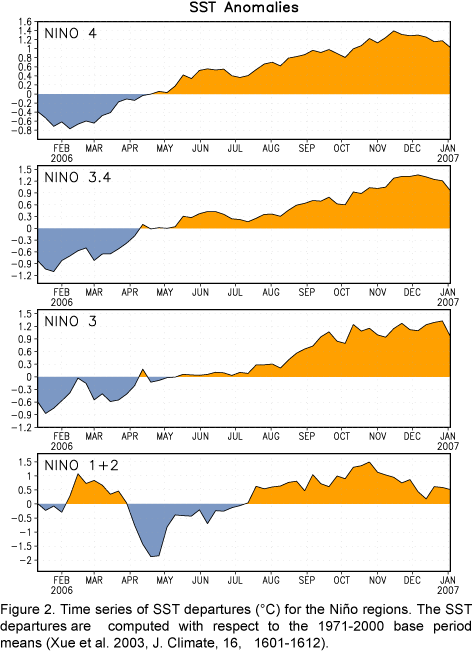
(Fig. 1). The latest SST departures in
the Niño regions are around 1.0ºC,
except near 0.5ºC
for Niño 1+2 (Fig. 2). The increase in SST
anomalies during the last half of 2006 was accompanied by weaker-than-average
low-level equatorial easterly winds across most of the equatorial Pacific and
negative values of the Southern Oscillation
Index (SOI). Collectively,
these oceanic and atmospheric anomalies indicated the development
of El Niño in the tropical Pacific.
Beginning in February 2006 the basin-wide upper ocean heat content
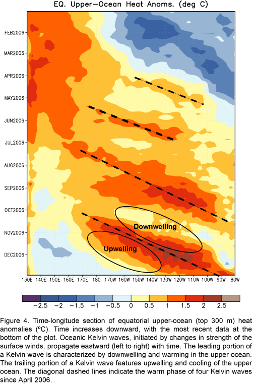
increased, and since early April 2006 positive anomalies have been observed (Fig. 3). The upper ocean heat content since
April 2006 has been modulated by oceanic Kelvin waves (Fig. 4), initiated by variations in the intensity of the low-level
equatorial easterly winds partly associated with Madden-Julian Oscillation (MJO)
activity. Four distinct Kelvin waves have occurred in the last nine months (Fig.
4), with the amplitude of each wave exceeding that of its predecessor.
The most recent Kelvin wave (bottom of Fig.
4) reached the west coast of South America during the last half of
December 2006, resulting in a warming of the subsurface and surface waters
along the coasts of Ecuador and northern Peru.
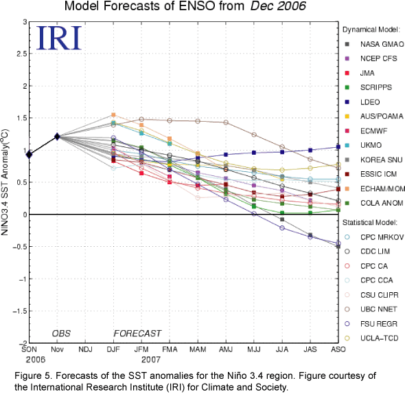
Most of the statistical and coupled models, including
the NCEP Climate Forecast System (CFS), indicate
that SST anomalies are near their peak and that decreasing anomalies are
likely during February-May 2007 (Fig.
5). Recent observed trends in the upper ocean tend to support those
forecasts. Decreasing upper-ocean heat content in the central equatorial
Pacific has been progressing east in association with the upwelling portion
of the most recent Kelvin wave. In the absence of any further Kelvin wave
activity, the upper-ocean heat content should return to near average in a few
months. However, there is considerable uncertainty in this outlook, given the
resurgence of MJO activity in late December 2006. It is possible that the
enhanced precipitation phase of the MJO, which is currently entering the
western tropical Pacific, might trigger a more persistent pattern of
cloudiness and precipitation over the anomalously warm waters of the central
equatorial Pacific during the next several weeks. If that occurs, then the
equatorial easterlies over the central Pacific will likely weaken possibly
leading to the initiation of a fifth Kelvin wave. Please refer to ENSO
Evolution, Status and Prediction Presentation available on the CPC El Niño/
La Niña
page for weekly updates on the latest conditions in the tropical Pacific (see
link below).
There is an increased probability of
observing El Niño-related effects over
North America during January-March 2007, including warmer-than-average
temperatures over western and central Canada, and over the northern United States,
wetter-than-average conditions over portions of the U.S. Gulf Coast and Florida, and
drier-than-average conditions in the Ohio Valley and in portions of the
Pacific Northwest. Global effects that can be expected during January-March include
drier-than-average conditions over portions of Malaysia, Indonesia, northern
and eastern Australia, some of the U.S.-affiliated islands in the tropical
North Pacific, northern South America and southeastern Africa,
and wetter-than-average conditions over central
South America (Uruguay, northeastern Argentina, southeastern Paraguay and
southern Brazil) and possibly along the coasts of Ecuador and northern Peru.
This discussion is a consolidated effort of NOAA and its funded institutions.
Oceanic and atmospheric conditions
are updated weekly on the Climate
Prediction Center website
(El Niño/La Niña
Current Conditions and Expert Discussions). Forecasts for the evolution of El Niño/La Niña are updated monthly in the
Forecast Forum section of CPC's Climate
Diagnostics Bulletin. The next ENSO Diagnostics Discussion is scheduled for
8
February 2007. To receive
an e-mail notification when the monthly ENSO Diagnostic Discussions are released, please send an e-mail
message
to: ncep.list.enso-update@noaa.gov.
|


