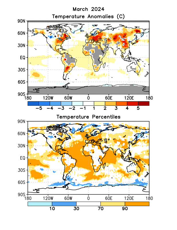
Skip Navigation Links www.nws.noaa.gov 
NOAA logo - Click to go to the NOAA home page National Weather Service   NWS logo - Click to go to the NWS home page
Climate Prediction Center
 

Climate Diagnostics Bulletin
Climate Diagnostics Bulletin - Home Climate Diagnostics Bulletin - Tropics Climate Diagnostics Bulletin - Forecast


  Extratropical Highlights

  Table of Indices  (Table 3)

  Global Surface Temperature  E1

  Temperature Anomalies (Land Only)  E2

  Global Precipitation  E3

  Regional Precip Estimates (a)  E4

  Regional Precip Estimates (b)  E5

  U.S. Precipitation  E6

  Northern Hemisphere

  Southern Hemisphere

  Stratosphere

  Appendix 2: Additional Figures

FEBRUARY 2024

FIGURE E1.  Surface temperature anomalies (Celsius, top) and surface temperature expressed as percentiles of the normal (Gaussian) distribution fit to the 1991-2020 base period data (bottom). Analysis is based on station data over land and on SST data over the oceans (top). Anomalies for station data are departures from the 1971-2000 base period means, while SST anomalies are departures from the 1991-2020 adjusted OI climatology. (Smith and Reynolds 1998, J. Climate, 11, 3320-3323). Regions with insufficient data for analysis in both figures are indicated by shading in the top figure only.


NOAA/ National Weather Service
NOAA Center for Weather and Climate Prediction
Climate Prediction Center
5830 University Research Court
College Park, Maryland 20740
Page Author: Climate Prediction Center Internet Team
Page Last Modified: March 2024
Disclaimer
Information Quality
Credits
Glossary
Privacy Policy
Freedom of Information Act (FOIA)
About Us
Career Opportunities